IMAGES TAKEN NEAR TO
Common Lane, POLEGATE, BN26 6SU
Introduction
This page details the photographs taken nearby to Common Lane, BN26 6SU by members of the Geograph project.
The Geograph project started in 2005 with the aim of publishing, organising and preserving representative images for every square kilometre of Great Britain, Ireland and the Isle of Man.

There are currently over 7.5m images from over14,400 individuals and you can help contribute to the project by visiting https://www.geograph.org.uk
Image Map
Images are licensed for reuse under creativecommons.org/licenses/by-sa/2.0
Notes
- Clicking on the map will re-center to the selected point.
- The higher the marker number, the further away the image location is from the centre of the postcode.
Image Listing (38 Images Found)
Images are licensed for reuse under creativecommons.org/licenses/by-sa/2.0
Image
Details
Distance
1
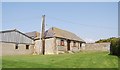
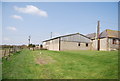
Flint Barn, Stonery Farm
Flint is used extensively in the South Downs region as a durable building material, due to a lack of any other suitable material.
Image: © N Chadwick
Taken: 12 Apr 2010
0.02 miles
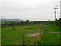
2
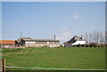
Stonery Farm
A turf and free range chicken Farm.
Image: © N Chadwick
Taken: 12 Apr 2010
0.03 miles
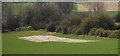
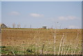
3
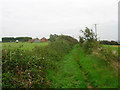
Stonery Farm
Taken from the bridleway that links Selmeston to Berwick Station. The bridleway follows the course of an old Roman road that ran from Pevensey Castle linking up other minor roads before heading towards Chichester. It was given the number 142 by the Roman road specialist Ivan Margery.
Image: © Simon Carey
Taken: 29 Aug 2008
0.03 miles
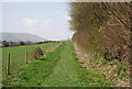
6
Vanguard Way
The long distance footpath follows the course of the bridleway from Berwick before turning south down the drive to Stonery Farm which is behind the hedge to the right.
Image: © Simon Carey
Taken: 29 Aug 2008
0.05 miles
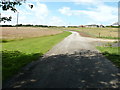
10
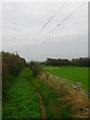
Birds on a Wire
On the telegraph poles that run parallel to the bridleway as it passes Stonery Farm. The bridleway runs along the course of an old Roman road than ran from Pevensey Castle to Chichester.
Image: © Simon Carey
Taken: 29 Aug 2008
0.09 miles