IMAGES TAKEN NEAR TO
Station Road, POLEGATE, BN26 6ST
Introduction
This page details the photographs taken nearby to Station Road, BN26 6ST by members of the Geograph project.
The Geograph project started in 2005 with the aim of publishing, organising and preserving representative images for every square kilometre of Great Britain, Ireland and the Isle of Man.

There are currently over 7.5m images from over14,400 individuals and you can help contribute to the project by visiting https://www.geograph.org.uk
Image Map
Images are licensed for reuse under creativecommons.org/licenses/by-sa/2.0
Notes
- Clicking on the map will re-center to the selected point.
- The higher the marker number, the further away the image location is from the centre of the postcode.
Image Listing (32 Images Found)
Images are licensed for reuse under creativecommons.org/licenses/by-sa/2.0
Image
Details
Distance
1
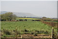
Cattle grazing near Berwick
The South Downs can be seen in the background.
Image: © N Chadwick
Taken: 24 Apr 2010
0.08 miles
2
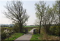
Cycle Path to Alfriston
Fairly new I believe as it certainly wasn't here when I cycled through chasing points in the days when this part of the county was all green squares. Runs parallel to Station Road until Old Leylands Barn before rejoining the road to its junction with the A27. Taken from the beginning point at the crossroads south of Berwick.
Image: © Simon Carey
Taken: 29 Aug 2008
0.09 miles
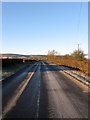
4
National cycle Route 2
Here the route runs parallel with Station Rd.
Image: © N Chadwick
Taken: 24 Apr 2010
0.10 miles
5
National Cycle Route 2 crosses a small stream near Berwick
Image: © N Chadwick
Taken: 24 Apr 2010
0.10 miles
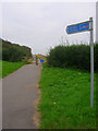
6
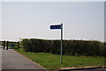
National cycleway 2 signpost, Station Rd
Image: © N Chadwick
Taken: 24 Apr 2010
0.10 miles
7
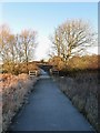
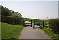
Berwick Way
Part of a combined pedestrian and cycle path that is planned to link Berwick Station with the village of Berwick. This new path was opened in 2006 and runs along the western side of Station Road between the junction with Common Lane and a spot a little to the north of Old Leylands Barn where it currently ends as the following phase has yet to be constructed. Here the frost covered path crosses a small brook, a tributary of the Cuckmere River.
Image: © Simon Carey
Taken: 2 Dec 2012
0.10 miles
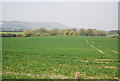
8
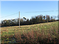
Third Common Field
The name of the field according to Berwick's 1838 tithe map that was once part of the old common that was enclosed in the 1820s and covered the northern end of the parish. The line of trees at the far end of the field mark the parish boundary between Berwick and Arlington.
Image: © Simon Carey
Taken: 2 Dec 2012
0.10 miles
9
Common Lane
As the name suggests this highway once ran through Berwick Common which was largely enclosed during the 1820s. It currently provides a convenient short cut for those wanting to access the C39 via the A27 without having to travel along the latter to the Drusilla's roundabout. The road itself was for a brief period the main east-west route between Lewes and Eastbourne until it was replaced in 1820 by a more direct route that is now the A27. Viewed from the junction with Station Road.
Image: © Simon Carey
Taken: 2 Dec 2012
0.13 miles
10
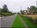
Station Road
The road to Berwick from Berwick. There are two settlements within the parish of Berwick, the old village built round the church and its farms the newer settlement which grew up around the railway station on the site of Berwick Common. The latter has the better facilities including a post office, general stores, pub and garage. The white cottage on the right is Crossways Cottage which overlooks the crossroads in the distance.
Image: © Simon Carey
Taken: 29 Aug 2008
0.14 miles