IMAGES TAKEN NEAR TO
Caneheath, POLEGATE, BN26 6SJ
Introduction
This page details the photographs taken nearby to Caneheath, BN26 6SJ by members of the Geograph project.
The Geograph project started in 2005 with the aim of publishing, organising and preserving representative images for every square kilometre of Great Britain, Ireland and the Isle of Man.

There are currently over 7.5m images from over14,400 individuals and you can help contribute to the project by visiting https://www.geograph.org.uk
Image Map
Images are licensed for reuse under creativecommons.org/licenses/by-sa/2.0
Notes
- Clicking on the map will re-center to the selected point.
- The higher the marker number, the further away the image location is from the centre of the postcode.
Image Listing (33 Images Found)
Images are licensed for reuse under creativecommons.org/licenses/by-sa/2.0
Image
Details
Distance
1
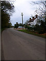
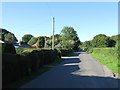
Old Oak Inn, Caneheath
Abbots Wood is to the left of the lane.
Image: © Simon Carey
Taken: 17 Nov 2007
0.07 miles
2
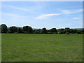
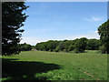
Little Field/House Field
The name of the fields according to Arlington's 1843 tithe map that have been joined together to make a larger unit. Little Field was in the foreground, House Field towards the far end.
Image: © Simon Carey
Taken: 1 Jun 2011
0.07 miles
3
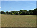
Pick Field
The name of the field according to Arlington's 1843 tithe map. The partially obscured building is the Old Oak Inn whilst beyond is the canopy of Abbot's Wood.
Image: © Simon Carey
Taken: 1 Jun 2011
0.08 miles
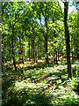
4
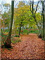
Abbots Wood
Autumn colours near Forest Lodge. The Abbots Wood land is owned by the Forestry Commission and is popular with the public.
Image: © Simon Carey
Taken: 17 Nov 2007
0.10 miles
5
Caneheath
The name of both the road and small hamlet that lies on the western edge of Abbot's Wood. The hamlet straggles down the western side of the road from the junction with Tye Hill Road to the Old Oak Inn.
Image: © Simon Carey
Taken: 26 Jun 2011
0.11 miles
6
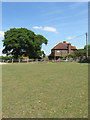
Primrose Farmhouse
Viewed from the footpath that links the Old Oak Inn to Bates Green Farm. Primrose Farm, formerly known as Caneheath Farm seems to be the site of the former parish poorhouse that was established in 1800 and closed in 1834.
Image: © Simon Carey
Taken: 1 Jun 2011
0.11 miles
7
Abbots Wood
Near the Old Oak Inn, Caneheath.
Image: © Simon Carey
Taken: 16 Jul 2006
0.13 miles
8
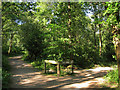
Trail Junction, Abbot's Wood
Abbot's Amble to the left, Oak Walk to the right. Abbot's Wood was once owned by the Abbot of Battle Abbey who utilised its resources into a profitable venture for the abbey. Now owned by the Forestry Commission with a large number of trails and paths that are open access. A popular dog walking spot.
Image: © Simon Carey
Taken: 3 Jun 2011
0.13 miles
9
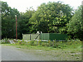
Storage units, Abbot's Wood
Presumably Forestry Commission units, supplied with electricity.
Image: © Robin Webster
Taken: 28 Aug 2011
0.13 miles
10
Peeked Field
The name of the field according to Arlington's 1843 tithe map which seems to derive from its triangular shape.
Image: © Simon Carey
Taken: 1 Jun 2011
0.13 miles