IMAGES TAKEN NEAR TO
Tye Hill Road, POLEGATE, BN26 6SH
Introduction
This page details the photographs taken nearby to Tye Hill Road, BN26 6SH by members of the Geograph project.
The Geograph project started in 2005 with the aim of publishing, organising and preserving representative images for every square kilometre of Great Britain, Ireland and the Isle of Man.

There are currently over 7.5m images from over14,400 individuals and you can help contribute to the project by visiting https://www.geograph.org.uk
Image Map
Images are licensed for reuse under creativecommons.org/licenses/by-sa/2.0
Notes
- Clicking on the map will re-center to the selected point.
- The higher the marker number, the further away the image location is from the centre of the postcode.
Image Listing (30 Images Found)
Images are licensed for reuse under creativecommons.org/licenses/by-sa/2.0
Image
Details
Distance
2
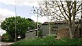
Bates Green Farm
The footpath from the Old Oak Inn heads down the drive then turns left. The farm is home to the Bluebell Walk and a number of farm trails around the surrounding fields. See http://www.bluebellwalk.co.uk/ for more information.
Image: © Simon Carey
Taken: 1 Jun 2011
0.03 miles
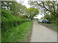
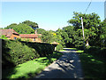
3
Tye Hill Road, Arlington
Looking North west. The building in the distance is part of Bate's Green Farm.
Image: © Kevin Gordon
Taken: 4 Nov 2008
0.04 miles
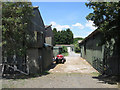
4
Family farm day at Bate's Green Farm
Incorporating a Bluebell walk through neighbouring woods.
Image: © Dave Spicer
Taken: 7 May 2012
0.05 miles
5
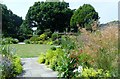
Gardens, Bate's Green Farm, Arlington
The gardens were open as part of the National Garden Scheme.
Image: © nick macneill
Taken: 14 Jul 2013
0.05 miles
6
Bates Green
Once a small green on Tye Hill Road which has long been enclosed though the original outline still remains beyond the hedges on either side as a gap between the lane and the fields. The house on the left is also called Bates Green and was originally an 18th century gamekeepers cottage built on the old green before it was extended and rebuilt in 1922. The garden is open to the public as part of the national gardens scheme and can be visited between June and September. See http://www.batesgreen.co.uk/ for information.
Image: © Simon Carey
Taken: 26 Jun 2011
0.05 miles
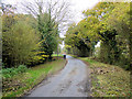
7
Tye Hill Road, Arlington
Looking from Tye Hill House towards Caneheath.
Image: © Kevin Gordon
Taken: 4 Nov 2008
0.06 miles
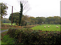
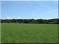
8
Small Profits
The name of the field according to Arlington's 1843 tithe map the name most likely deriving from the poor yield from it. Viewed from the footpath that links Bate's Green to Wilbees Road.
Image: © Simon Carey
Taken: 1 Jun 2011
0.06 miles
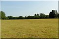
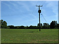
10
Poor Field
The name of the field according to Arlington's 1843 tithe map. The name can derive from either a low quality yielding field or one that was used to subsidise the local poor rates, as Image lies on the opposite side of Tye Hill Road I'm guessing that the first explanation covers this field. Abbot's Wood can be seen in the distance.
Image: © Simon Carey
Taken: 1 Jun 2011
0.10 miles