IMAGES TAKEN NEAR TO
Chilver Bridge Road, POLEGATE, BN26 6SB
Introduction
This page details the photographs taken nearby to Chilver Bridge Road, BN26 6SB by members of the Geograph project.
The Geograph project started in 2005 with the aim of publishing, organising and preserving representative images for every square kilometre of Great Britain, Ireland and the Isle of Man.

There are currently over 7.5m images from over14,400 individuals and you can help contribute to the project by visiting https://www.geograph.org.uk
Image Map
Images are licensed for reuse under creativecommons.org/licenses/by-sa/2.0
Notes
- Clicking on the map will re-center to the selected point.
- The higher the marker number, the further away the image location is from the centre of the postcode.
Image Listing (92 Images Found)
Images are licensed for reuse under creativecommons.org/licenses/by-sa/2.0
Image
Details
Distance
3
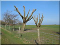
Cut back trees south of Arlington Reservoir
Image: © Paul Gillett
Taken: 13 Mar 2014
0.05 miles
4
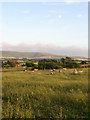
Sloehill Cottages
View from the drive to Polhill Farm with Windover Hill, which contains the Long Man of Wilmington, providing the backdrop.
Image: © Simon Carey
Taken: 3 Jul 2009
0.06 miles
5
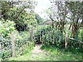
Gate on footpath near Arlington Reservoir
Image: © PAUL FARMER
Taken: 21 Jun 2015
0.06 miles
6
Sloefield Cottages
Viewed from the footpath to Chilverbridge House that runs along the peak of the small hillock south of Arlington Reservoir. Just beyond the cottages is Chilver Bridge Farm and beyond that the northern escarpment of the Downs with Wilmington Hill to the right and Folkington Hill to the left.
Image: © Simon Carey
Taken: 29 Aug 2008
0.07 miles
7
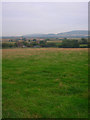
View SE from the south side of Arlington Reservoir
Image: © Ian Hawfinch
Taken: 6 Mar 2021
0.08 miles
8
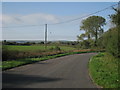
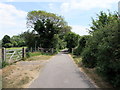
Chilver Bridge Road
Lane to south of Arlington Reservoir.
Image: © Oast House Archive
Taken: 10 Oct 2010
0.08 miles
9
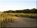
Dried Pond Bed near Arlington Reservoir
The footpath that links Chilver Bridge Road to Polhill Farm lies to the right.
Image: © Simon Carey
Taken: 3 Jul 2009
0.08 miles
10
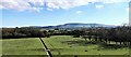
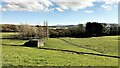
View towards Windover Hill from the south side of Arlington Reservoir
This is a cross-grid shot. Even the fields in the foreground lie in the square to the south of the camera. Unusual concrete-lined drainage ditches traverse these fields, as you can see in the photo.
Image: © Ian Hawfinch
Taken: 6 Mar 2021
0.09 miles