IMAGES TAKEN NEAR TO
Wilbees Road, POLEGATE, BN26 6RU
Introduction
This page details the photographs taken nearby to Wilbees Road, BN26 6RU by members of the Geograph project.
The Geograph project started in 2005 with the aim of publishing, organising and preserving representative images for every square kilometre of Great Britain, Ireland and the Isle of Man.

There are currently over 7.5m images from over14,400 individuals and you can help contribute to the project by visiting https://www.geograph.org.uk
Image Map
Images are licensed for reuse under creativecommons.org/licenses/by-sa/2.0
Notes
- Clicking on the map will re-center to the selected point.
- The higher the marker number, the further away the image location is from the centre of the postcode.
Image Listing (42 Images Found)
Images are licensed for reuse under creativecommons.org/licenses/by-sa/2.0
Image
Details
Distance
2
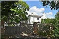
Endlewick House
A large house dating from the early 19th century on Wilbees Road. It was originally the vicarage until the 1950s.
Image: © Simon Carey
Taken: 26 Jun 2011
0.01 miles
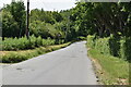
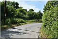
6
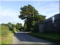
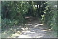
Road from Arlington to Caneheath, East Sussex
Image: © nick macneill
Taken: 12 Jun 2009
0.06 miles
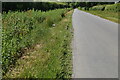
8
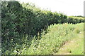
Sheeps Ley
The name of the field according to Arlington's 1843 tithe map viewed from Wilbees Road.
Image: © Simon Carey
Taken: 26 Jun 2011
0.08 miles
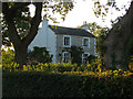
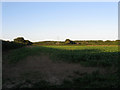
10
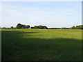
Banks Field
The name of the field according to Arlington's 1843 tithe map that has been expanded to include Image to the west. The hedgerow at the far end of the field marks the course of Wilbees Road whilst the trees to right that of Whiteing Lane. The house visible in the distance is Endlewick.
Image: © Simon Carey
Taken: 2 Jun 2011
0.09 miles