IMAGES TAKEN NEAR TO
Hayreed Lane, POLEGATE, BN26 6RR
Introduction
This page details the photographs taken nearby to Hayreed Lane, BN26 6RR by members of the Geograph project.
The Geograph project started in 2005 with the aim of publishing, organising and preserving representative images for every square kilometre of Great Britain, Ireland and the Isle of Man.

There are currently over 7.5m images from over14,400 individuals and you can help contribute to the project by visiting https://www.geograph.org.uk
Image Map
Images are licensed for reuse under creativecommons.org/licenses/by-sa/2.0
Notes
- Clicking on the map will re-center to the selected point.
- The higher the marker number, the further away the image location is from the centre of the postcode.
Image Listing (20 Images Found)
Images are licensed for reuse under creativecommons.org/licenses/by-sa/2.0
Image
Details
Distance
1
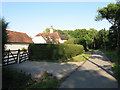
Hayreed House
Dating from the late 17th or early 18th century. The road is Hayreed Lane which dates back to Roman times when it was the local route connecting Chichester to Pevensey Castle. It remained the main east west route throughout the centuries and briefly became the main Lewes-Eastbourne turnpike in 1792 before it was superseded by the shorter and more direct turnpike to the south which is now the main A27. The lane provides access for this house and Pickhams further to the west before becoming a restricted byway.
Image: © Simon Carey
Taken: 11 Jun 2011
0.02 miles
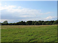
2
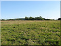
Hayreeds
The name of the field according to Wilmington's 1838 tithe map that lies to the rear of Image from whence it gets its name.
Image: © Simon Carey
Taken: 11 Jun 2011
0.06 miles
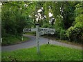
3
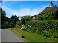
Hayreed
Another small single dwelling in the area between Arlington and Wilmington. This one on a lane that goes to nowhere.
Image: © Simon Carey
Taken: 16 Jul 2006
0.07 miles
4
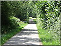
Hayreed Lane, near Arlington, East Sussex
Image: © nick macneill
Taken: 15 Jul 2011
0.09 miles
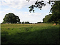
5
Hovens
The name of the field according to Wilmington's 1838 tithe map viewed from the footpath that links Monken Pyn to Hayreed Lane.
Image: © Simon Carey
Taken: 11 Jun 2011
0.17 miles
7
Hayreeds
The name of the field according to Wilmington's 1838 tithe map that runs next to Thornwell Road on the right.
Image: © Simon Carey
Taken: 11 Jun 2011
0.18 miles
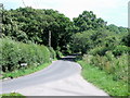
8
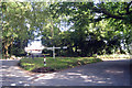
Former Crossroads, Old Thornwell (1)
Now the junction of Thornwell Road and Robin Post Lane. The lane straight ahead dates back to the Roman period and was until 1819 the major east-west route north of the Downs. When a new turnpike, the current A27, was opened in 1819 the old route became a backwater and the eastwards leg from here to Swines Hill, now Polegate, closed most likely to compensate the landowner, Folkington Manor, for loss of land in construction of the new road. The north-south route was an old droving road linking the village of Wilmington with wood pastures at the northern end of the parish as well as a through route to the market town of Hailsham. Robin Post Lane is now a dead end for motor vehicles though not for bicycles, horses and walkers as it still allows access. See also Image
Image: © Simon Carey
Taken: 11 Jun 2011
0.20 miles
10
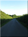
Bayley's Lane
Links the junction at Plackets Corner to another near Hayreeds. The high hedges shade the lane from the late evening sun.
Image: © Simon Carey
Taken: 26 Jun 2011
0.21 miles