IMAGES TAKEN NEAR TO
POLEGATE, BN26 6QU
Introduction
This page details the photographs taken nearby to BN26 6QU by members of the Geograph project.
The Geograph project started in 2005 with the aim of publishing, organising and preserving representative images for every square kilometre of Great Britain, Ireland and the Isle of Man.

There are currently over 7.5m images from over14,400 individuals and you can help contribute to the project by visiting https://www.geograph.org.uk
Image Map
Images are licensed for reuse under creativecommons.org/licenses/by-sa/2.0
Notes
- Clicking on the map will re-center to the selected point.
- The higher the marker number, the further away the image location is from the centre of the postcode.
Image Listing (11 Images Found)
Images are licensed for reuse under creativecommons.org/licenses/by-sa/2.0
Image
Details
Distance
1
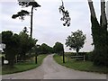
Entrance to Priesthawes and Priesthawes Farm
Also footpath Westham 19a.
Image: © Dave Spicer
Taken: 2 Jul 2013
0.11 miles
2
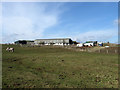
Priesthawes Farm
Viewed from the footpath that links the farm with Hankham.
Image: © Simon Carey
Taken: 20 Feb 2010
0.11 miles
3
Four Acres
The name of the field according to the 1838 tithe map. The wall at the far end of the field marks the western boundary of Priesthawes.
Image: © Simon Carey
Taken: 21 Mar 2010
0.12 miles
4
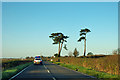
Pines by Hailsham Road
They are at the start of the drive to Priesthawes over to the right.
Image: © Robin Webster
Taken: 17 Nov 2011
0.15 miles
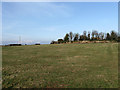
5
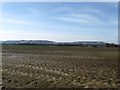
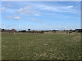
Kiln Field
The name of the field according to the 1838 tithe map. The South Downs can be seen in the distance with Combe Hill and Willingdon Hill on the left and Folkington Hill and Wilmington Hill to the right.
Image: © Simon Carey
Taken: 20 Feb 2010
0.17 miles
6
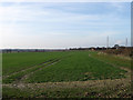
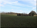
Tanners
The name of this section of the field according to the 1838 tithe map which has been extended to include Sixteen Acres, First Wish and Birch Wish. Old Court Cottages are in the distance on the right.
Image: © Simon Carey
Taken: 21 Mar 2010
0.19 miles
7
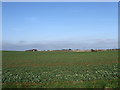
Warehouse Field
The name of the field according to the 1838 tithe map. The hamlet of Hankham can be seen in the distance to the right.
Image: © Simon Carey
Taken: 21 Mar 2010
0.19 miles
8
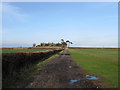
Farm Track to Priesthawes
The track crosses the B2104 then continues up the drive beyond the pines at its entrance. The track is also a footpath that links Priesthawes to Shepham Lane.
Image: © Simon Carey
Taken: 21 Mar 2010
0.19 miles
9
Barn Meadow
The name of the field according to the 1838 tithe map. The house in the distance is Lusteds.
Image: © Simon Carey
Taken: 20 Feb 2010
0.19 miles
10
The Six Acres
The name of the field according to the 1838 tithe map. The trees and bushes in the dip to the right contain a large pond.
Image: © Simon Carey
Taken: 20 Feb 2010
0.20 miles