IMAGES TAKEN NEAR TO
Northern Avenue, POLEGATE, BN26 6HQ
Introduction
This page details the photographs taken nearby to Northern Avenue, BN26 6HQ by members of the Geograph project.
The Geograph project started in 2005 with the aim of publishing, organising and preserving representative images for every square kilometre of Great Britain, Ireland and the Isle of Man.

There are currently over 7.5m images from over14,400 individuals and you can help contribute to the project by visiting https://www.geograph.org.uk
Image Map
Images are licensed for reuse under creativecommons.org/licenses/by-sa/2.0
Notes
- Clicking on the map will re-center to the selected point.
- The higher the marker number, the further away the image location is from the centre of the postcode.
Image Listing (39 Images Found)
Images are licensed for reuse under creativecommons.org/licenses/by-sa/2.0
Image
Details
Distance
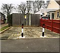
2
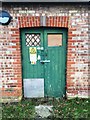
Electricity sub station, Central Avenue
Image: © Alex McGregor
Taken: 10 Feb 2015
0.07 miles
4
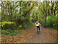
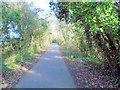
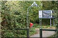
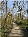
Cyclists on route 21
Two cyclists head towards Eastbourne on National Cycle Network route 21.
Image: © Stephen Craven
Taken: 10 Nov 2012
0.13 miles
5
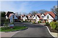
New houses at West Close
All appear to be sold, but unoccupied.
Image: © Oast House Archive
Taken: 16 Apr 2018
0.14 miles
6
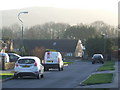
Dover Road, Polegate
Dover Road in Polegate, with the South Downs in the background.
Image: © Malc McDonald
Taken: 12 Feb 2011
0.14 miles
7
Houses under construction, West Close
Image: © Oast House Archive
Taken: 16 Mar 2017
0.14 miles
8
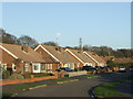
Dover Road, Polegate
Bungalows on Dover Road in Polegate.
Image: © Malc McDonald
Taken: 12 Feb 2011
0.16 miles