IMAGES TAKEN NEAR TO
Cornflower Crescent, POLEGATE, BN26 6GE
Introduction
This page details the photographs taken nearby to Cornflower Crescent, BN26 6GE by members of the Geograph project.
The Geograph project started in 2005 with the aim of publishing, organising and preserving representative images for every square kilometre of Great Britain, Ireland and the Isle of Man.

There are currently over 7.5m images from over14,400 individuals and you can help contribute to the project by visiting https://www.geograph.org.uk
Image Map
Images are licensed for reuse under creativecommons.org/licenses/by-sa/2.0
Notes
- Clicking on the map will re-center to the selected point.
- The higher the marker number, the further away the image location is from the centre of the postcode.
Image Listing (38 Images Found)
Images are licensed for reuse under creativecommons.org/licenses/by-sa/2.0
Image
Details
Distance
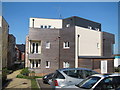
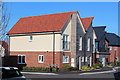
1
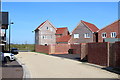
Chaucer Business Park
Newly constructed units await sale at the eastern edge of the business park. The access road is also new.
Image: © Simon Carey
Taken: 21 Mar 2010
0.12 miles