IMAGES TAKEN NEAR TO
Balmoral Mews, POLEGATE, BN26 6FW
Introduction
This page details the photographs taken nearby to Balmoral Mews, BN26 6FW by members of the Geograph project.
The Geograph project started in 2005 with the aim of publishing, organising and preserving representative images for every square kilometre of Great Britain, Ireland and the Isle of Man.

There are currently over 7.5m images from over14,400 individuals and you can help contribute to the project by visiting https://www.geograph.org.uk
Image Map
Images are licensed for reuse under creativecommons.org/licenses/by-sa/2.0
Notes
- Clicking on the map will re-center to the selected point.
- The higher the marker number, the further away the image location is from the centre of the postcode.
Image Listing (42 Images Found)
Images are licensed for reuse under creativecommons.org/licenses/by-sa/2.0
Image
Details
Distance
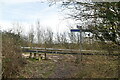
1
Upper Hip Holes
The name of the field according to the 1838 tithe map and viewed from Shepham Lane.
Image: © Simon Carey
Taken: 21 Mar 2010
0.07 miles
2
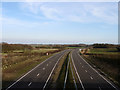
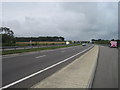
Polegate By-Pass
Built in the early 1990s to take both the A27 and A22 away from the congested roads of Polegate. Both A roads share this road between Cophall Roundabout and the junction with Golden Jubilee Way when the former continues east along the Pevensey By-Pass whilst the latter goes south to Eastbourne.
Image: © Simon Carey
Taken: 21 Mar 2010
0.12 miles
3
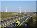
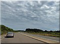
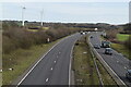
Polegate Bypass and Shepham Windfarm
Image: © Oast House Archive
Taken: 16 Mar 2017
0.12 miles
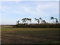
7
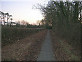
Shepham Lane, Polegate
Former country lane now part of the national cycle network. As a result nature has been allowed to encroach on its borders. This view looks south just beyond the bridge over the A27 and just before it swings right to enter Polegate.
Image: © Simon Carey
Taken: 21 Jan 2006
0.15 miles
9
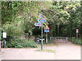
The Cuckoo Trail, Polegate, East Sussex
The way beyond the gate, Shepham Lane, was a public road, but it has now been downgraded to a byway no longer used by cars.
Image: © nick macneill
Taken: 14 Oct 2010
0.17 miles