IMAGES TAKEN NEAR TO
Victoria Road, POLEGATE, BN26 6BY
Introduction
This page details the photographs taken nearby to Victoria Road, BN26 6BY by members of the Geograph project.
The Geograph project started in 2005 with the aim of publishing, organising and preserving representative images for every square kilometre of Great Britain, Ireland and the Isle of Man.

There are currently over 7.5m images from over14,400 individuals and you can help contribute to the project by visiting https://www.geograph.org.uk
Image Map
Images are licensed for reuse under creativecommons.org/licenses/by-sa/2.0
Notes
- Clicking on the map will re-center to the selected point.
- The higher the marker number, the further away the image location is from the centre of the postcode.
Image Listing (48 Images Found)
Images are licensed for reuse under creativecommons.org/licenses/by-sa/2.0
Image
Details
Distance
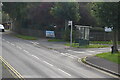
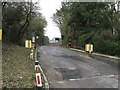
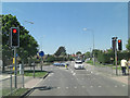
2
Hailsham Road, Polegate
Taken at the junction of Victoria Road (on the right)
Image: © Kevin Gordon
Taken: 22 Jul 2008
0.05 miles
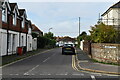
3
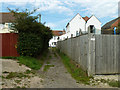
Back alley, Polegate
This connects Brook Street with Victoria Road. It forms a T-junction with an alley along the backs of the houses on these two roads, the junction being about where the camera is.
Image: © Robin Webster
Taken: 3 Sep 2011
0.10 miles
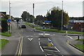

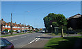
10
B2247 Station Road junction with High Street
Image: © Stuart Logan
Taken: 27 May 2012
0.17 miles