IMAGES TAKEN NEAR TO
Station Road, POLEGATE, BN26 6BD
Introduction
This page details the photographs taken nearby to Station Road, BN26 6BD by members of the Geograph project.
The Geograph project started in 2005 with the aim of publishing, organising and preserving representative images for every square kilometre of Great Britain, Ireland and the Isle of Man.

There are currently over 7.5m images from over14,400 individuals and you can help contribute to the project by visiting https://www.geograph.org.uk
Image Map
Images are licensed for reuse under creativecommons.org/licenses/by-sa/2.0
Notes
- Clicking on the map will re-center to the selected point.
- The higher the marker number, the further away the image location is from the centre of the postcode.
Image Listing (109 Images Found)
Images are licensed for reuse under creativecommons.org/licenses/by-sa/2.0
Image
Details
Distance
1

Scrubland, Station Road, Polegate
It may look like just scrubland, but it is in fact the line of the old railway from Polegate to Eridge.
Image: © nick macneill
Taken: 24 Feb 2012
0.04 miles
2
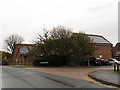
Cycle route sign, School Lane
The sign on the corner of School Lane (foreground) and Station Road points north towards the Cuckoo Trail and west towards the town centre.
Image: © Stephen Craven
Taken: 10 Nov 2012
0.08 miles
3
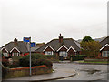
Solar panels, Old School Close, Polegate
Several houses in this recent development sport roof panels. This was not a good day for solar power though.
Image: © Stephen Craven
Taken: 10 Nov 2012
0.09 miles
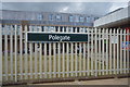
5
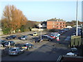
Polegate station car park
This photo was taken from the footbridge at Polegate station, looking over the station car park.
Image: © Malc McDonald
Taken: 12 Feb 2011
0.10 miles
6
Gilda Crescent, Polegate
Gilda Crescent leads off from the High Street, Polegate.
Image: © Kevin Gordon
Taken: 22 Jul 2008
0.11 miles
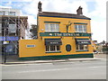
7
The Dinkum Pub, High Street, Polegate
This pub was unimaginatively named the "Polegate Inn" but was always known by locals as the Dinkum. In the First World War injured Australian troops were stationed at nearby Willingdon a mile away. Part of their recuperation process was walking across to the pub in Polegate (a great incentive!) and they nicknamed it "The Dinkum". The pub changed its name in the 1980s and a pub sign showing an injured soldier being helped by a nurse was commissioned from local artist Keith Pettit.
Image: © Kevin Gordon
Taken: 22 Jul 2008
0.11 miles
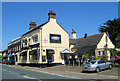
9
The Dinkum, Polegate
Harvey's Pub in the High Street near Polegate Station
Image: © Paul Gillett
Taken: 18 Feb 2015
0.12 miles
10
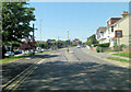
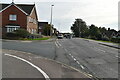
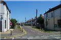
B2247 Station Road south of Junction Street
Image: © Stuart Logan
Taken: 27 May 2012
0.12 miles