IMAGES TAKEN NEAR TO
High Street, POLEGATE, BN26 6AE
Introduction
This page details the photographs taken nearby to High Street, BN26 6AE by members of the Geograph project.
The Geograph project started in 2005 with the aim of publishing, organising and preserving representative images for every square kilometre of Great Britain, Ireland and the Isle of Man.

There are currently over 7.5m images from over14,400 individuals and you can help contribute to the project by visiting https://www.geograph.org.uk
Image Map
Images are licensed for reuse under creativecommons.org/licenses/by-sa/2.0
Notes
- Clicking on the map will re-center to the selected point.
- The higher the marker number, the further away the image location is from the centre of the postcode.
Image Listing (106 Images Found)
Images are licensed for reuse under creativecommons.org/licenses/by-sa/2.0
Image
Details
Distance
1
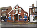
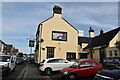
Polegate Free Church
A place of worship on the High Street.
Image: © Stephen Craven
Taken: 10 Nov 2012
0.00 miles

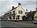
5
The Dinkham sign
See previous sign Image
Image: © Oast House Archive
Taken: 11 May 2019
0.02 miles
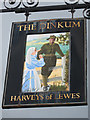
6
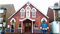
The Dinkum, Polegate
Harveys of Lewes pub on High Street.
Image: © Oast House Archive
Taken: 12 Sep 2011
0.03 miles
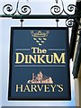
7
The Dinkham sign
Sign for Image], a Harveys of Lewes pub on High Street.
Image: © Oast House Archive
Taken: 12 Sep 2011
0.03 miles
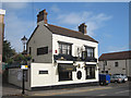
9
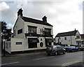
The Dinkum, High Street, Polegate
The Dinkum was known as The Polegate Inn until about a hundred years ago.
Image: © PAUL FARMER
Taken: 8 Feb 2014
0.03 miles