IMAGES TAKEN NEAR TO
West Close, POLEGATE, BN26 5UZ
Introduction
This page details the photographs taken nearby to West Close, BN26 5UZ by members of the Geograph project.
The Geograph project started in 2005 with the aim of publishing, organising and preserving representative images for every square kilometre of Great Britain, Ireland and the Isle of Man.

There are currently over 7.5m images from over14,400 individuals and you can help contribute to the project by visiting https://www.geograph.org.uk
Image Map
Images are licensed for reuse under creativecommons.org/licenses/by-sa/2.0
Notes
- Clicking on the map will re-center to the selected point.
- The higher the marker number, the further away the image location is from the centre of the postcode.
Image Listing (368 Images Found)
Images are licensed for reuse under creativecommons.org/licenses/by-sa/2.0
Image
Details
Distance
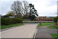
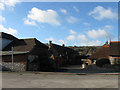
2
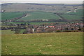
Alfriston seen from the South Downs Way above the village
Image: © N Chadwick
Taken: 14 Apr 2010
0.02 miles
5
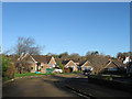
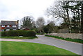
Smuggler's Close
A cul de sac off Deans Road built during the 1960s when much of the western side of the village was developed.
Image: © Simon Carey
Taken: 1 Jan 2013
0.04 miles
8
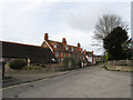
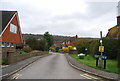
West Street
Viewed from the junction with Sloe Lane. The street was once the main highway linking Alfriston to Lewes but was downgraded during the early 19th century when a new turnpike was built that is currently the A27. The one-storey flint building to the left is Blacksmith's Lodge, the former village forge, whilst the large semi detached houses beyond were built in the first decade of the 20th century.
Image: © Simon Carey
Taken: 30 Dec 2012
0.05 miles
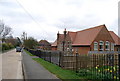
9
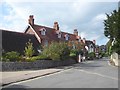
Forge Cottages
Modern infill development off West Street built on the site of the former village forge.
Image: © Simon Carey
Taken: 1 Jan 2013
0.06 miles
10
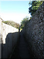
Rope Walk
Narrow twitten that runs from parallel with High Street and West Street with a branch that joins the former and a northern junction with the latter. The flint walls to the right separate it from the rear of the old properties whilst the fence on the left does the same with the newer ones in Smuggler's Close.
Image: © Simon Carey
Taken: 1 Jan 2013
0.06 miles