IMAGES TAKEN NEAR TO
Sloe Lane, POLEGATE, BN26 5UP
Introduction
This page details the photographs taken nearby to Sloe Lane, BN26 5UP by members of the Geograph project.
The Geograph project started in 2005 with the aim of publishing, organising and preserving representative images for every square kilometre of Great Britain, Ireland and the Isle of Man.

There are currently over 7.5m images from over14,400 individuals and you can help contribute to the project by visiting https://www.geograph.org.uk
Image Map
Images are licensed for reuse under creativecommons.org/licenses/by-sa/2.0
Notes
- Clicking on the map will re-center to the selected point.
- The higher the marker number, the further away the image location is from the centre of the postcode.
Image Listing (533 Images Found)
Images are licensed for reuse under creativecommons.org/licenses/by-sa/2.0
Image
Details
Distance
1
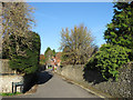
Sloe Lane
Viewed from the junction with West Street. The lane is an old highway that heads north to the hamlet of Winton.
Image: © Simon Carey
Taken: 11 Nov 2012
0.01 miles
2
Sloe Lane
Small lane off North Street joining another lane from West Street before becoming a bridleway that heads out of the village towards Winton, Berwick Court and the Dickers. Once the northern route out of the village.
Image: © Simon Carey
Taken: 13 Sep 2008
0.01 miles
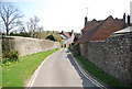
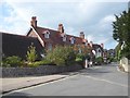
3
Sloe Lane, Alfriston (3)
A narrow lane entering Alfriston
Image: © N Chadwick
Taken: 12 Apr 2010
0.02 miles
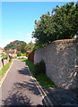
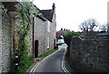
4
Flint walls along Sloe Lane
Very characteristic of this part of the South Downs.
Image: © N Chadwick
Taken: 12 Apr 2010
0.02 miles
5
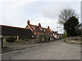
West Street
Viewed from the junction with Sloe Lane. The street was once the main highway linking Alfriston to Lewes but was downgraded during the early 19th century when a new turnpike was built that is currently the A27. The one-storey flint building to the left is Blacksmith's Lodge, the former village forge, whilst the large semi detached houses beyond were built in the first decade of the 20th century.
Image: © Simon Carey
Taken: 30 Dec 2012
0.03 miles
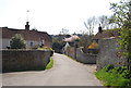
8
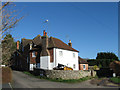
Quince Cottage
Located where the two branches of Sloe Lane meet the cottage dates from the 18th century. The red bricked building beyond is Paddocks which, as the name suggests, was converted from former stables.
Image: © Simon Carey
Taken: 1 Jan 2013
0.03 miles
9
Alfriston Lock-up
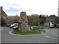
This curious building is to be found in the Dene car park between West Street and North Street. It is constructed of flint with brickwork reveals to its door and two windows (the second, smaller, window being in the top half of the side facing away from us). The flat top is roofed with slates. No records exist of its construction or original purpose although various roles have been conjectured including a dovecot, gun store, shot tower, kiln and lock-up (holding cell), the latter being the most likely according to the Oddities of Sussex website https://web.archive.org/web/20080723182653/http://www.yeoldesussexpages.com/oddities/lockup.htm
Image: © Andy Potter
Taken: 3 Feb 2008
0.03 miles
10
![Alfriston features [5]](https://s2.geograph.org.uk/geophotos/07/23/37/7233734_ce20e986_120x120.jpg)
Alfriston features [5]
In Sloe Lane is this 18th century flint garden wall to Brook Furlong. Listed, grade II, with details at: https://historicengland.org.uk/listing/the-list/list-entry/1191417
Alfriston is a village in East Sussex, some 6½ miles northwest of Eastbourne and 3½ miles northeast of Seaford. The village lies on the west bank of the Cuckmere River. There is evidence of occupation in the Neolithic period, with several long barrows on the surrounding downs. The village is home to The Star Inn, built in 1345 to accommodate monks and pilgrims en route from Battle Abbey to Chichester Cathedral. Also in the village is the Old Clergy House, the first building acquired by the National Trust in 1898.
Image: © Michael Dibb
Taken: 6 May 2022
0.04 miles