IMAGES TAKEN NEAR TO
Alfriston, POLEGATE, BN26 5TJ
Introduction
This page details the photographs taken nearby to BN26 5TJ by members of the Geograph project.
The Geograph project started in 2005 with the aim of publishing, organising and preserving representative images for every square kilometre of Great Britain, Ireland and the Isle of Man.

There are currently over 7.5m images from over14,400 individuals and you can help contribute to the project by visiting https://www.geograph.org.uk
Image Map
Images are licensed for reuse under creativecommons.org/licenses/by-sa/2.0
Notes
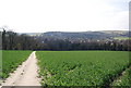
- Clicking on the map will re-center to the selected point.
- The higher the marker number, the further away the image location is from the centre of the postcode.
Image Listing (586 Images Found)
Images are licensed for reuse under creativecommons.org/licenses/by-sa/2.0
Image
Details
Distance
2
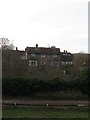
The Tanneries
The house was built after the Second World War and lies on higher ground above The Spots.
Image: © Simon Carey
Taken: 27 Jan 2013
0.01 miles
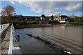
3
Alfriston from the Cuckmere footbridge
Heavy rain has swollen the Cuckmere river. Seen from the footbridge that carries the South Downs Way.
Image: © David M Clark
Taken: 12 Nov 2022
0.01 miles
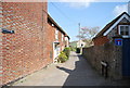
4
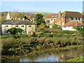
River Lane, Alfriston, East Sussex
Image: © Oast House Archive
Taken: 7 Nov 2008
0.01 miles
5
The Cuckmere in Flood
The river Cuckmere in flood and threatening low lying houses on the edge of Alfriston.
Image: © Peter Jeffery
Taken: 7 Jan 2016
0.02 miles
6
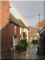
River Lane, Alfriston
The route the South Downs Way takes out of the Village to the east.
Image: © N Chadwick
Taken: 12 Apr 2010
0.02 miles
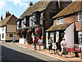
8

A flint built cottage, High St
A very useful building material derived from the chalk.
Image: © N Chadwick
Taken: 12 Apr 2010
0.02 miles
9
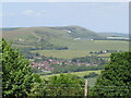
Alfriston and Firle Beacon
A path leads west from Winchester's Pond to offer these views over Alfriston, with the old chalk pits of Bopeep visible just below Firle Beacon.
Image: © David M Clark
Taken: 25 May 2020
0.02 miles
10
![Alfriston buildings [5]](https://s3.geograph.org.uk/geophotos/07/23/15/7231583_08938805_120x120.jpg)
Alfriston buildings [5]
Built as a Congregational church and dated 1801. Later the United Reformed Church. Now the Old Chapel Centre and used as a village hall. Constructed of brick, refaced with cement in the mid 19th century, all under a hipped slate roof. There is a contemporary flint wall along the south side of the church-yard. Listed, grade II, with details at: https://historicengland.org.uk/listing/the-list/list-entry/1043354
Alfriston is a village in East Sussex, some 6½ miles northwest of Eastbourne and 3½ miles northeast of Seaford. The village lies on the west bank of the Cuckmere River. There is evidence of occupation in the Neolithic period, with several long barrows on the surrounding downs. The village is home to The Star Inn, built in 1345 to accommodate monks and pilgrims en route from Battle Abbey to Chichester Cathedral. Also in the village is the Old Clergy House, the first building acquired by the National Trust in 1898.
Image: © Michael Dibb
Taken: 6 May 2022
0.03 miles