IMAGES TAKEN NEAR TO
Ropewalk, POLEGATE, BN26 5SU
Introduction
This page details the photographs taken nearby to Ropewalk, BN26 5SU by members of the Geograph project.
The Geograph project started in 2005 with the aim of publishing, organising and preserving representative images for every square kilometre of Great Britain, Ireland and the Isle of Man.

There are currently over 7.5m images from over14,400 individuals and you can help contribute to the project by visiting https://www.geograph.org.uk
Image Map
Images are licensed for reuse under creativecommons.org/licenses/by-sa/2.0
Notes
- Clicking on the map will re-center to the selected point.
- The higher the marker number, the further away the image location is from the centre of the postcode.
Image Listing (584 Images Found)
Images are licensed for reuse under creativecommons.org/licenses/by-sa/2.0
Image
Details
Distance
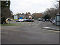
1
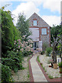
![Alfriston houses [17]](https://s2.geograph.org.uk/geophotos/07/23/27/7232722_5d39ea46_120x120.jpg)
Alfriston houses [17]
Rope Walk Cottage and The Croft, in Rope Walk, were built in the 18th century. Constructed of brick, stuccoed on the ground floor, above tile-hung, all under a tile roof. Listed, grade II, with details at: https://historicengland.org.uk/listing/the-list/list-entry/1353262
Alfriston is a village in East Sussex, some 6½ miles northwest of Eastbourne and 3½ miles northeast of Seaford. The village lies on the west bank of the Cuckmere River. There is evidence of occupation in the Neolithic period, with several long barrows on the surrounding downs. The village is home to The Star Inn, built in 1345 to accommodate monks and pilgrims en route from Battle Abbey to Chichester Cathedral. Also in the village is the Old Clergy House, the first building acquired by the National Trust in 1898.
Image: © Michael Dibb
Taken: 6 May 2022
0.01 miles
2
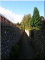
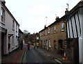
Rope Walk
Small twitten that runs around the rear of the old part of the village and as its name suggests was the area where rope was made and laid out in the past. This part links Market Square with Smugglers Close.
Image: © Simon Carey
Taken: 13 Sep 2008
0.02 miles
4
The South Downs Way
Leaving the centre of Alfriston heading west.
Image: © Trevor Harris
Taken: 26 Aug 2012
0.02 miles
6
Deans Road, Alfriston
The South Downs Way passes through the village, and a marker post can be seen at the opposite corner.
Image: © David Purchase
Taken: 20 Oct 2014
0.03 miles

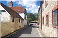
8
West Street
The view immediately next to the junction with Image The cottages on both sides date back to the 18th century. The street was originally the main road to Lewes until the early 19th century when a new turnpike to Eastbourne, by then a more important destination than Alfriston, was built.
Image: © Simon Carey
Taken: 30 Dec 2012
0.03 miles
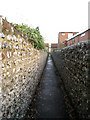
9
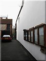
Rope Walk
A narrow twitten heading west from High Street and a reminder of the former trade of rope making which was carried out in the fields behind the houses. The building to the right is the Post Office.
Image: © Simon Carey
Taken: 30 Dec 2012
0.03 miles