IMAGES TAKEN NEAR TO
The Street, POLEGATE, BN26 5SQ
Introduction
This page details the photographs taken nearby to The Street, BN26 5SQ by members of the Geograph project.
The Geograph project started in 2005 with the aim of publishing, organising and preserving representative images for every square kilometre of Great Britain, Ireland and the Isle of Man.

There are currently over 7.5m images from over14,400 individuals and you can help contribute to the project by visiting https://www.geograph.org.uk
Image Map
Images are licensed for reuse under creativecommons.org/licenses/by-sa/2.0
Notes
- Clicking on the map will re-center to the selected point.
- The higher the marker number, the further away the image location is from the centre of the postcode.
Image Listing (43 Images Found)
Images are licensed for reuse under creativecommons.org/licenses/by-sa/2.0
Image
Details
Distance
1
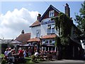
The Giants Rest, Wilmington
Website: http://www.giantsrest.co.uk/
Image: © Paul Gillett
Taken: 9 Aug 2012
0.01 miles
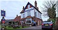
2
The Giant's Rest, Wilmington, East Sussex
Image: © Oast House Archive
Taken: 14 Feb 2009
0.02 miles
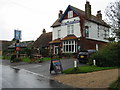
4
The Giant's Rest, Wilmington
The Giant's Rest public house in Wilmington, East Sussex. The pub is close to the viewing and access points to the hill figure called 'The Long Man'.
Image: © Len Williams
Taken: 18 Jan 2014
0.03 miles
5
Footpath Long Man 8 to the A27 at Wilmington
Image: © Dave Spicer
Taken: 9 Jul 2012
0.05 miles
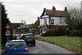
6
The Old Forge
Located at the southern end of Wilmington Green that is now south of the crossroads. Now converted into a residence one of a number within the village whose name belies its former use. The footpath heads off to the east of the village towards a bridleway that links Wilmington to Folkington.
Image: © Simon Carey
Taken: 11 Jun 2011
0.05 miles
7
Wilmington Green looking south
Wilmington Green actually straddles two grid squares, the southern part of it looks toward the village itself with the A27 in the foreground.
Image: © Simon Carey
Taken: 16 Jul 2006
0.05 miles
8
Mebis
The name of the house in view that lies behind the other cottages that front onto The Street, Wilmington's village street. Seems to have been built sometime between 1930 and 1950.
Image: © Simon Carey
Taken: 11 Jun 2011
0.07 miles
9
Lewes Road
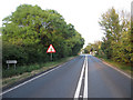
A rare quiet moment on the busy A27 as it heads towards the crossroads at Wilmington. The road was constructed as a turnpike in 1819 to shorten the carriage route between Lewes and the expanding resort of Eastbourne
Image: © Simon Carey
Taken: 2 Jun 2011
0.07 miles
10
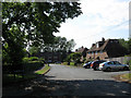
Adesfield
Small cul-de-sac off The Street in the village of Wilmington. The houses on the right seem to have been built in the 1950s those at the end during the 1960s.
Image: © Simon Carey
Taken: 11 Jun 2011
0.07 miles