IMAGES TAKEN NEAR TO
Wilmington, POLEGATE, BN26 5RS
Introduction
This page details the photographs taken nearby to BN26 5RS by members of the Geograph project.
The Geograph project started in 2005 with the aim of publishing, organising and preserving representative images for every square kilometre of Great Britain, Ireland and the Isle of Man.

There are currently over 7.5m images from over14,400 individuals and you can help contribute to the project by visiting https://www.geograph.org.uk
Image Map
Images are licensed for reuse under creativecommons.org/licenses/by-sa/2.0
Notes
- Clicking on the map will re-center to the selected point.
- The higher the marker number, the further away the image location is from the centre of the postcode.
Image Listing (27 Images Found)
Images are licensed for reuse under creativecommons.org/licenses/by-sa/2.0
Image
Details
Distance
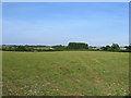
1
Site of Milton Barn
Another derelict barn with little to show of its former existence. It ceased being marked on maps from the 1970s which gives a rough date of its dereliction.
Image: © Simon Carey
Taken: 2 Jun 2011
0.04 miles

4
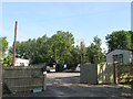
Milton Field
A small plot of land next to the A27 at Milton Gate seems to have been turned into a permanent travellers site. There is nothing on the aerial pictures which means it has not been here for long.
Image: © Simon Carey
Taken: 2 Jun 2011
0.07 miles
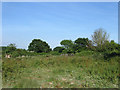
5
Plumbleys Field
The name of the field according to Arlington's 1843 tithe map that lies at the junction of the Wealdway and restricted byway to Milton Crossing.
Image: © Simon Carey
Taken: 2 Jun 2011
0.08 miles
6
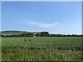
Site of Wilmington Aerodrome (3)
Another view of Image from the Wealdway. The only surviving structure is the former hangar on the right which was converted into a barn when the site became Milton Gate Farm during the 1970s. Beyond is Wilmington Hill.
Image: © Simon Carey
Taken: 2 Jun 2011
0.09 miles
7
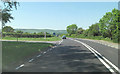
A27 Lewes Road junction with Milton Street lane
Image: © Stuart Logan
Taken: 27 May 2012
0.09 miles
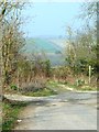
9
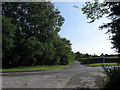
Milton Gate
The name of the crossroads derives from the position of a former turnpike tollgate that existed here from the construction of what is now the modern A27 in 1819. The older route originally ran north-south and survives only as the lane to Milton Street. The old road north joined Thornwell Road south of Monkyn Pyn and has now been reduced in status to a restricted byway.
Image: © Simon Carey
Taken: 2 Jun 2011
0.10 miles
10

Wealdway crossing the A27 at Milton Gate
Image: © Dave Spicer
Taken: 9 Jul 2012
0.10 miles