IMAGES TAKEN NEAR TO
Jevington, POLEGATE, BN26 5QJ
Introduction
This page details the photographs taken nearby to BN26 5QJ by members of the Geograph project.
The Geograph project started in 2005 with the aim of publishing, organising and preserving representative images for every square kilometre of Great Britain, Ireland and the Isle of Man.

There are currently over 7.5m images from over14,400 individuals and you can help contribute to the project by visiting https://www.geograph.org.uk
Image Map
Images are licensed for reuse under creativecommons.org/licenses/by-sa/2.0
Notes
- Clicking on the map will re-center to the selected point.
- The higher the marker number, the further away the image location is from the centre of the postcode.
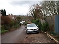
Image Listing (189 Images Found)
Images are licensed for reuse under creativecommons.org/licenses/by-sa/2.0
Image
Details
Distance
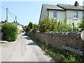
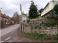
1
South Downs Way entering Jevington on un-named lane
Image: © Dave Spicer
Taken: 19 Jul 2012
0.01 miles
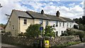
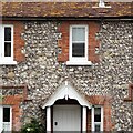
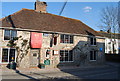
8
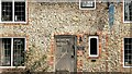
Monks Rest
These are now called "Hungry Monk Cottages" but used to be the famous "Hungry Monk" restaurant, where banoffee pie was invented. The restaurant closed in 2012.
Image: © Ian Hawfinch
Taken: 17 Apr 2022
0.02 miles