IMAGES TAKEN NEAR TO
St. Johns Road, POLEGATE, BN26 5BN
Introduction
This page details the photographs taken nearby to St. Johns Road, BN26 5BN by members of the Geograph project.
The Geograph project started in 2005 with the aim of publishing, organising and preserving representative images for every square kilometre of Great Britain, Ireland and the Isle of Man.

There are currently over 7.5m images from over14,400 individuals and you can help contribute to the project by visiting https://www.geograph.org.uk
Image Map
Images are licensed for reuse under creativecommons.org/licenses/by-sa/2.0
Notes
- Clicking on the map will re-center to the selected point.
- The higher the marker number, the further away the image location is from the centre of the postcode.
Image Listing (119 Images Found)
Images are licensed for reuse under creativecommons.org/licenses/by-sa/2.0
Image
Details
Distance
1

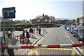
Looking across the High Street towards Polegate News and The Polegate Community Caf
Image: © Basher Eyre
Taken: 7 Dec 2015
0.03 miles
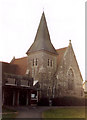
2
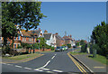
St John's Road , Polegate
Named after the nearby parish church.
Image: © Kevin Gordon
Taken: 22 Jul 2008
0.03 miles

8
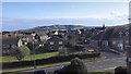
Polgate Station view of Combe Hill on Horizon
Image: © James Emmans
Taken: 23 Apr 2016
0.05 miles
10

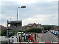
Level Crossing, Polegate
West of the station
Image: © Paul Gillett
Taken: 24 Feb 2012
0.05 miles