IMAGES TAKEN NEAR TO
Courtland Road, POLEGATE, BN26 5BE
Introduction
This page details the photographs taken nearby to Courtland Road, BN26 5BE by members of the Geograph project.
The Geograph project started in 2005 with the aim of publishing, organising and preserving representative images for every square kilometre of Great Britain, Ireland and the Isle of Man.

There are currently over 7.5m images from over14,400 individuals and you can help contribute to the project by visiting https://www.geograph.org.uk
Image Map
Images are licensed for reuse under creativecommons.org/licenses/by-sa/2.0
Notes
- Clicking on the map will re-center to the selected point.
- The higher the marker number, the further away the image location is from the centre of the postcode.
Image Listing (16 Images Found)
Images are licensed for reuse under creativecommons.org/licenses/by-sa/2.0
Image
Details
Distance
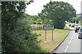
1
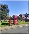
Postbox and Telephone Kiosk, Brightling Road, Polegate
Image: © PAUL FARMER
Taken: 7 Apr 2024
0.06 miles
2
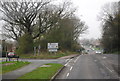
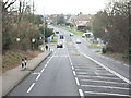
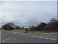
Entering Polegate, Eastbourne Rd
The A2270 north out of Eastbourne.
Image: © N Chadwick
Taken: 31 Mar 2011
0.11 miles
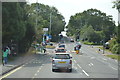
8
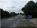
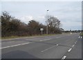
A22 Polegate looking north
The photo is taken from the Tesco garage forecourt under a leaden sky.
Image: © nick macneill
Taken: 20 Aug 2009
0.17 miles