IMAGES TAKEN NEAR TO
Walnut Walk, POLEGATE, BN26 5AE
Introduction
This page details the photographs taken nearby to Walnut Walk, BN26 5AE by members of the Geograph project.
The Geograph project started in 2005 with the aim of publishing, organising and preserving representative images for every square kilometre of Great Britain, Ireland and the Isle of Man.

There are currently over 7.5m images from over14,400 individuals and you can help contribute to the project by visiting https://www.geograph.org.uk
Image Map
Images are licensed for reuse under creativecommons.org/licenses/by-sa/2.0
Notes
- Clicking on the map will re-center to the selected point.
- The higher the marker number, the further away the image location is from the centre of the postcode.
Image Listing (114 Images Found)
Images are licensed for reuse under creativecommons.org/licenses/by-sa/2.0
Image
Details
Distance
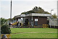
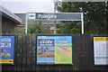
1
Polgate Station view of Combe Hill on Horizon
Image: © James Emmans
Taken: 23 Apr 2016
0.01 miles
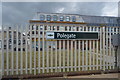
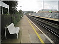
2
Polegate Station
on the East Coastway Line between Lewes and Eastbourne
Image: © Paul Gillett
Taken: 24 Feb 2012
0.03 miles
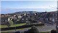
6
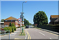
The Black Path, Polegate
This runs alongside the railway and used to be an unmade road from the old Polegate Station to the High Street. It was owned by the railway and was called the Black Path because cinders from the steam engines was used to surface it. When it was taken over and surfaced by the council in the 1980s it was named "Black Path Road" but locals used to tape over the word "road" so it is now just called "Black Path". The new Polegate Station can be seen on the far left.
Image: © Kevin Gordon
Taken: 22 Jul 2008
0.04 miles
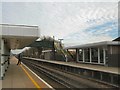
7
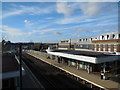
Polegate Railway Station
view from the footbridge
Image: © Paul Gillett
Taken: 18 Feb 2015
0.04 miles
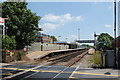
8
Polegate railway station, Sussex
Opened in 1846 by the London & Brighton Railway, soon to become part of the London Brighton & South Coast Railway, on the line from Lewes to Hastings, this station closed in 1881. It was replaced by one 300m behind the camera position. However, history came full circle when this station was rebuilt and reopened in 1986.
View west towards Berwick and Lewes.
Image: © Nigel Thompson
Taken: 24 Sep 2014
0.04 miles
9

Polegate station - footbridge
The footbridge looks quite recent.
Image: © Stephen Craven
Taken: 10 Nov 2012
0.04 miles