IMAGES TAKEN NEAR TO
Whitehawk Road, BRIGHTON, BN2 5ZJ
Introduction
This page details the photographs taken nearby to Whitehawk Road, BN2 5ZJ by members of the Geograph project.
The Geograph project started in 2005 with the aim of publishing, organising and preserving representative images for every square kilometre of Great Britain, Ireland and the Isle of Man.

There are currently over 7.5m images from over14,400 individuals and you can help contribute to the project by visiting https://www.geograph.org.uk
Image Map
Images are licensed for reuse under creativecommons.org/licenses/by-sa/2.0
Notes
- Clicking on the map will re-center to the selected point.
- The higher the marker number, the further away the image location is from the centre of the postcode.
Image Listing (22 Images Found)
Images are licensed for reuse under creativecommons.org/licenses/by-sa/2.0
Image
Details
Distance
1

Whitehawk Primary school
School Website: http://www.whitehawk.brighton-hove.sch.uk/
Image: © Paul Gillett
Taken: 13 Jul 2013
0.03 miles
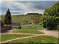
2
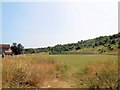
The Pitch, Whitehawk
Green area at the foot of Whitehawk Hill, in the background can be seen an horse and cart being used during the Whitehawk festival
Image: © Paul Gillett
Taken: 13 Jul 2013
0.08 miles
3
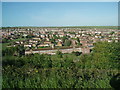
Whitehawk viewed from Manor Hill
Whitehawk infant school is in the foreground
Image: © Paul Gillett
Taken: 19 May 2009
0.09 miles
4

Horse and Cart beneath Whitehawk hill
During the annual Whitehawk Festival
Image: © Paul Gillett
Taken: 13 Jul 2013
0.11 miles
5
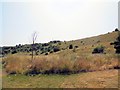
Whitehawk Camp
Known locally as "the steep hill", this is a short cut to Manor Hill and the racecourse from Whitehawk Estate
Whitehawk Camp is one of Britain’s earliest stone age monuments. The hill was chosen some 5,500 years ago as the site for a series of circular ditches and banks which marked the hill as an area for feasting, burials and other activities of a ritual nature http://www.brighton-hove.gov.uk/content/leisure-and-libraries/parks-and-green-spaces/whitehawk-camp
It reaches 396 feet above sea level and measures 950 feet by 700 feet. It is made up of four concentric ditches broken up by causeways. The first written mention of the camp (as "White Hawke Hill") was in 1587. http://en.wikipedia.org/wiki/Whitehawk_Camp
Image: © Paul Gillett
Taken: 13 Jul 2013
0.12 miles
6
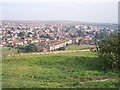
Whitehawk, Brighton
Taken from the Iron Age Hill Fort of White Hawk looking down on the area of Brighton adopting the name.
Image: © Bob Embleton
Taken: 9 Sep 2005
0.12 miles
7
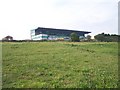
Whitehawk Camp, Brighton (with the Grandstand behind)
A neolithic camp dating from 2700 BC covering some 12 acres. Excavated in the 1920s and 1930s. much destroyed by the racecourse and property developers.
Image: © Bob Embleton
Taken: 9 Sep 2005
0.12 miles
8

Lintott Avenue (South) Park
Near to St Cuthman's church during the annual Whitehawk festival
Image: © Paul Gillett
Taken: 13 Jul 2013
0.14 miles
9
Whitehawk Hill
Viewed from near St Cuthman's church, the grandstand on Brighton Racecourse can be seen in the background, In recent years sheep have been bought onto the hill mainly as a cheap means of keeping the grass short http://www.brighton-hove.gov.uk/index.cfm?request=c1179479
As a youngster I regularly played on this hill which was known to locals as "The Steep Hill" The chalk path still visible is a short cut from Whitehawk to Manor hill
Image: © Paul Gillett
Taken: 12 May 2010
0.14 miles
10

The Pitch, Whitehawk
Green area at the foot of Whitehawk Hill, the Crew Club can be seen in the background
Image: © Paul Gillett
Taken: 13 Jul 2013
0.14 miles