IMAGES TAKEN NEAR TO
Sheepcote Valley, BRIGHTON, BN2 5TS
Introduction
This page details the photographs taken nearby to Sheepcote Valley, BN2 5TS by members of the Geograph project.
The Geograph project started in 2005 with the aim of publishing, organising and preserving representative images for every square kilometre of Great Britain, Ireland and the Isle of Man.

There are currently over 7.5m images from over14,400 individuals and you can help contribute to the project by visiting https://www.geograph.org.uk
Image Map
Images are licensed for reuse under creativecommons.org/licenses/by-sa/2.0
Notes
- Clicking on the map will re-center to the selected point.
- The higher the marker number, the further away the image location is from the centre of the postcode.
Image Listing (33 Images Found)
Images are licensed for reuse under creativecommons.org/licenses/by-sa/2.0
Image
Details
Distance
1
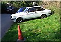
Ford Escort Mark 2, Whitehawk, Brighton
Image: © nick macneill
Taken: 15 Sep 2012
0.06 miles
2
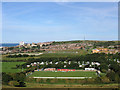
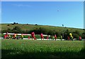
The Enclosed Ground, Whitehawk FC
Home to Whitehawk since the late 1950s. The club began life as Whitehawk & Manor Hill Old Boys in 1952 and have been a consistent Sussex County league team since then. They were promoted to Ryman League One South in 2009/10 and just missed out on the play-offs for the Ryman League premier the following season. Since the demise of Withdean they are the only other football club of any consequence within the city and currently have plans to at least get to Conference level which involves expanding the ground this season utilising some of the old seating from Withdean stadium which are currently 'on loan' to Newhaven Town of Sussex County League Two.
Immediately behind the ground is Sheepcote Valley camping and caravan park which municipally owned and as you climb the slopes come to Stanley Deason Leisure Centre located in a former school that was closed ten years ago due to persistently poor results.To the left of the school are the all weather pitches used for hockey and five a side football leagues though their exposed nature to the south westerlies off the sea make them a difficult place to play on at times. Whitehawk Hill and its transmitter is in the distance with the large building on the left being Thomas Kemp Tower which is part of the Royal Sussex Hospital complex.
The view is from Red Hill.
Image: © Simon Carey
Taken: 29 Aug 2011
0.07 miles
3
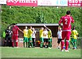
Water break, the Enclosed Ground, home of Whitehawk FC
The game was between Whitehawk and Thurrock in the Ryman Premier League. The home team wearing the red kit won the game by five goals to one.
Image: © nick macneill
Taken: 15 Sep 2012
0.08 miles
4
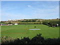
Rugby Pitches, East Brighton Park
Looking across Black Rock Valley towards Whitehawk hill in the distance. The park was laid out in 1925 and remains hugely popular today.
Image: © Simon Carey
Taken: 29 Aug 2011
0.08 miles
5
The Enclosed Ground, home of Whitehawk FC
The game was between Whitehawk and Thurrock in the Ryman Premier League. The home team wearing the red kit won the game by five goals to one.
Image: © nick macneill
Taken: 15 Sep 2012
0.08 miles
6
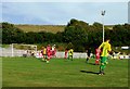
The Enclosed Ground, home of Whitehawk FC
The game was between Whitehawk and Thurrock in the Ryman Premier League. The home team wearing the red kit won the game by five goals to one.
Image: © nick macneill
Taken: 15 Sep 2012
0.10 miles
7
East Brighton Park
Taken on Christmas day 2009
Image: © Paul Gillett
Taken: 25 Dec 2009
0.15 miles
8
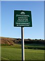
Emergency landing sign
I have played and walked here many times since I was a child, never realised I may have been committing a crime.
Image: © Paul Gillett
Taken: 25 Dec 2009
0.15 miles
10
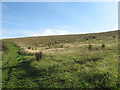
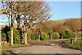
Sheepcote Valley
Following a track that runs through this area of open access land. Sheepcote Valley is northern end of Black Rock Valley that lies to the south.
Image: © Simon Carey
Taken: 29 Aug 2011
0.16 miles