IMAGES TAKEN NEAR TO
Swanborough Place, BRIGHTON, BN2 5PZ
Introduction
This page details the photographs taken nearby to Swanborough Place, BN2 5PZ by members of the Geograph project.
The Geograph project started in 2005 with the aim of publishing, organising and preserving representative images for every square kilometre of Great Britain, Ireland and the Isle of Man.

There are currently over 7.5m images from over14,400 individuals and you can help contribute to the project by visiting https://www.geograph.org.uk
Image Map
Images are licensed for reuse under creativecommons.org/licenses/by-sa/2.0
Notes
- Clicking on the map will re-center to the selected point.
- The higher the marker number, the further away the image location is from the centre of the postcode.
Image Listing (29 Images Found)
Images are licensed for reuse under creativecommons.org/licenses/by-sa/2.0
Image
Details
Distance
1

High Rises, Whitehawk
Located in the valley which give a strange perspective when viewed from the steep sides of Race Hill. The transmitter on Whitehawk Hill is visible to the right whilst the white building in the distance is Marine Gate which overlooks Brighton Marina.
Image: © Simon Carey
Taken: 29 Aug 2011
0.01 miles

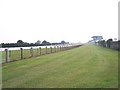
3
View of South Coast from East Brighton
View south to English Channel at East Brighton. Wilson Avenue (Pictured) bisects Brighton racecourse. Gates to municipal tip on left.
Image: © Mark Arrowsmith
Taken: Unknown
0.09 miles
4
Pipped at the post - Brighton Racecourse.
Looking along to the grandstand from near the pedestrian underpass. Took this one day before, but submitted it one day after Simon's photo - the race is on!.
Image: © Bob Embleton
Taken: 9 Sep 2005
0.09 miles
5

Tunnel beneath Brighton Racecourse
This pedestrian tunnel passes underneath to gain access to the Whitehawk area of the town.
Image: © Bob Embleton
Taken: 9 Sep 2005
0.09 miles
6
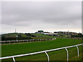
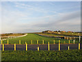
Towards the finishing line, Brighton Racecourse
The course is in effect a U shape, having started in square TQ3405 it heads north then turns west running parallel with Warren Road, crossing Wilson Avenue before turning south again at this point with 4 furlongs to go. The first grandstand was erected in 1788 and rebuilt over intermittent intervals. To the left of the grandstand is the radio transmitter on Whitehawk Hill to the right, Brighton General Hospital. This building's original function was a Workhouse and was deliberately built on Race Hill as it overlooks central Brighton.
Image: © Simon Carey
Taken: 10 Sep 2005
0.14 miles
7
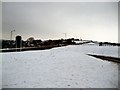
Brighton Race Hill - snowscene
Along the Warren Road towards Woodingdean
Image: © Paul Gillett
Taken: 12 Jan 2010
0.14 miles
8
Brighton Racecourse
Looking across Image as the track heads towards the peak of Race Hill then turns south towards the grandstand and finishing line.
Image: © Simon Carey
Taken: 29 Aug 2011
0.18 miles
9
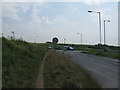
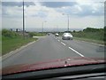
Bear Road junction with Race Hill
The Brighton Racecourse is in the distance.
Image: © Dave Spicer
Taken: 12 Aug 2012
0.18 miles
10
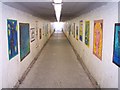
Inside the Underpass
Beneath the racecourse. Access to Whitehawk area of Brighton
Image: © Bob Embleton
Taken: 9 Sep 2005
0.19 miles