IMAGES TAKEN NEAR TO
Marlow Road, BRIGHTON, BN2 5NB
Introduction
This page details the photographs taken nearby to Marlow Road, BN2 5NB by members of the Geograph project.
The Geograph project started in 2005 with the aim of publishing, organising and preserving representative images for every square kilometre of Great Britain, Ireland and the Isle of Man.

There are currently over 7.5m images from over14,400 individuals and you can help contribute to the project by visiting https://www.geograph.org.uk
Image Map
Images are licensed for reuse under creativecommons.org/licenses/by-sa/2.0
Notes
- Clicking on the map will re-center to the selected point.
- The higher the marker number, the further away the image location is from the centre of the postcode.
Image Listing (87 Images Found)
Images are licensed for reuse under creativecommons.org/licenses/by-sa/2.0
Image
Details
Distance
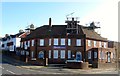
1
Whitehawk Inn
Former pub now used as a community learning base a function which it has fulfilled since 1999 http://www.whinn.org.uk/
Image: © Paul Gillett
Taken: 14 Mar 2013
0.04 miles
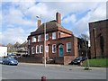
2
Whitehawk Inn, Whitehawk Road, Whitehawk, Brighton
Opened as a pub around 1937 and closed towards the end of the 1990s. Since 1999 it has been a community and education centre. Located on the corner of Marlow Road.
Image: © Simon Carey
Taken: 13 Nov 2015
0.05 miles
3
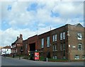
Whitehawk Bus Garage
Based at the Broadway
Image: © Paul Gillett
Taken: 14 Mar 2013
0.05 miles
4
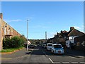
Henley Road, Whitehawk, Brighton
A residential road that links Whitehawk Road to Wilson Avenue that was built during the 1930s. On the left is Whitehawk Bus Depot.
Image: © Simon Carey
Taken: 13 Nov 2015
0.05 miles
5
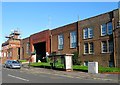
Whitehawk Bus Depot, Whitehawk Road, Whitehawk, Brighton
Built in the 1930s originally for trolley buses and still used as a small garage for services starting in the eastern part of the city.
Image: © Simon Carey
Taken: 13 Nov 2015
0.06 miles
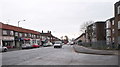
6
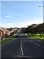
Wilson Avenue
Built in the 1930s to provide access for the new estates at Whitehawk and Woodingdean. Viewed from the junction with Roedean Road it heads north to Warren Road.
Image: © Simon Carey
Taken: 29 Aug 2011
0.06 miles
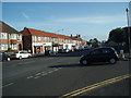
7
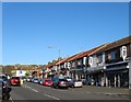
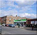
The Broadway, Whitehawk Road, Whitehawk, Brighton
A parade of shops built in the 1930s at the southern end of the suburb.
Image: © Simon Carey
Taken: 13 Nov 2015
0.06 miles
9
Whitehawk Broadway
viewed from bottom of Manor Hill
Image: © Paul Gillett
Taken: 19 May 2009
0.07 miles