IMAGES TAKEN NEAR TO
Downash Close, BRIGHTON, BN2 5HQ
Introduction
This page details the photographs taken nearby to Downash Close, BN2 5HQ by members of the Geograph project.
The Geograph project started in 2005 with the aim of publishing, organising and preserving representative images for every square kilometre of Great Britain, Ireland and the Isle of Man.

There are currently over 7.5m images from over14,400 individuals and you can help contribute to the project by visiting https://www.geograph.org.uk
Image Map
Images are licensed for reuse under creativecommons.org/licenses/by-sa/2.0
Notes
- Clicking on the map will re-center to the selected point.
- The higher the marker number, the further away the image location is from the centre of the postcode.
Image Listing (21 Images Found)
Images are licensed for reuse under creativecommons.org/licenses/by-sa/2.0
Image
Details
Distance
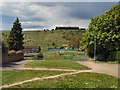
1

Lintott Avenue (South) Park
Near to St Cuthman's church during the annual Whitehawk festival
Image: © Paul Gillett
Taken: 13 Jul 2013
0.03 miles
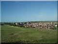
2
Whitehawk Hill
Viewed from near St Cuthman's church, the grandstand on Brighton Racecourse can be seen in the background, In recent years sheep have been bought onto the hill mainly as a cheap means of keeping the grass short http://www.brighton-hove.gov.uk/index.cfm?request=c1179479
As a youngster I regularly played on this hill which was known to locals as "The Steep Hill" The chalk path still visible is a short cut from Whitehawk to Manor hill
Image: © Paul Gillett
Taken: 12 May 2010
0.03 miles
3

Lintott Avenue (South) Park
The park was formerly in Lintott Avenue before it was demolished in the early 1980's as part of the development of Whitehawk, it was completed in 1988 http://www.24hourmuseum.org.uk/brightonandhove/local/TRA22073.html?ixsid=
Image: © Paul Gillett
Taken: 12 May 2010
0.06 miles
4
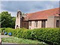
St Cuthman's church
St. Cuthman's Church was originally erected in Lintott Avenue in 1937, but was destroyed on 16 August 1943 by a German bomb with a church-warden buried alive. The new church was built in 1951-2 http://www.mybrightonandhove.org.uk/page_id__6550_path__0p114p462p795p.aspx
Image: © Paul Gillett
Taken: 12 May 2010
0.06 miles
5
North Whitehawk
viewed from near Brighton Racecourse at the top of Manor Hill
Image: © Paul Gillett
Taken: 19 May 2009
0.08 miles
6

St Cuthman's Church, Whitehawk
On the day of the Whitehawk Festival
St. Cuthman's Church was originally erected in Lintott Avenue in 1937, but was destroyed on 16 August 1943 by a German bomb with a church-warden buried alive. The new church was built in 1951-2 http://www.mybrightonandhove.org.uk/page_id__6550_path__0p114p462p795p.aspx
Image: © Paul Gillett
Taken: 13 Jul 2013
0.08 miles
7
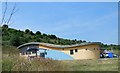
The Crew Club, Whitehawk
The Crew Club was established in 1999 following the sad loss of life of Jay Kensitt a local young person. Since then the club has supported thousands of young people with their educational, personal and social development. The Crew Club along with its statutory and voluntary sector partners now provides a wide range of services including Youth Work, Foundation Learning programmes and Holiday Provision for young people with Special Needs and Disabilities, Apprenticeship opportunities, Participatory budgeting projects and music production and performance. http://www.crewclub.co.uk/
Image: © Paul Gillett
Taken: 13 Jul 2013
0.09 miles
8

The Pitch, Whitehawk
Green area at the foot of Whitehawk Hill, the Crew Club can be seen in the background
Image: © Paul Gillett
Taken: 13 Jul 2013
0.10 miles
9

Whitehawk Primary school
School Website: http://www.whitehawk.brighton-hove.sch.uk/
Image: © Paul Gillett
Taken: 13 Jul 2013
0.10 miles
10

Horse and Cart beneath Whitehawk hill
During the annual Whitehawk Festival
Image: © Paul Gillett
Taken: 13 Jul 2013
0.11 miles