IMAGES TAKEN NEAR TO
Robin Dene, BRIGHTON, BN2 5EX
Introduction
This page details the photographs taken nearby to Robin Dene, BN2 5EX by members of the Geograph project.
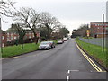
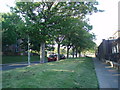
The Geograph project started in 2005 with the aim of publishing, organising and preserving representative images for every square kilometre of Great Britain, Ireland and the Isle of Man.

There are currently over 7.5m images from over14,400 individuals and you can help contribute to the project by visiting https://www.geograph.org.uk
Image Map
Images are licensed for reuse under creativecommons.org/licenses/by-sa/2.0
Notes
- Clicking on the map will re-center to the selected point.
- The higher the marker number, the further away the image location is from the centre of the postcode.
Image Listing (127 Images Found)
Images are licensed for reuse under creativecommons.org/licenses/by-sa/2.0
Image
Details
Distance
3
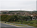
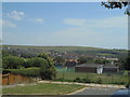
Brighton view, with radio mast
View from Roedean Road
Image: © Keith Edkins
Taken: 21 Sep 2012
0.03 miles
4
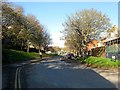
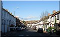
Manor Road, Brighton
Built in the late 1930s on the former site of Manor Farm. The road links the B2118 at the junction of Church Place and Bristol Gardens with Manor Hill.
Image: © Simon Carey
Taken: 13 Nov 2015
0.03 miles
7
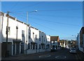
Prince's Terrace, Kemp Town, Brighton
The original Prince's Terrace are the white buildings on the left which were built in the 1860s. The road was then extended to Bristol Street in the first decade of the 20th century.
Image: © Simon Carey
Taken: 13 Nov 2015
0.08 miles
8
View east from Bristol Gate, Kemp Town, Brighton
Image: © Christopher Hilton
Taken: 6 Jul 2017
0.08 miles
9
Sussex Row, Bristol Gardens, Kemp Town, Brighton
The small terrace of eight houses were built in the mid 2000s on the site of the former Clyde Arms, a public house that operated from the 1880s until its closure in 2005. Bristol Gardens is the B2118.
Image: © Simon Carey
Taken: 13 Nov 2015
0.09 miles
10
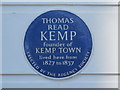
Blue plaque re Thomas Kemp, Sussex Square, BN2
The location of this blue plaque is shown in Image
Image: © Mike Quinn
Taken: 19 Apr 2012
0.10 miles