IMAGES TAKEN NEAR TO
Bowring Way, BRIGHTON, BN2 5DG
Introduction
This page details the photographs taken nearby to Bowring Way, BN2 5DG by members of the Geograph project.
The Geograph project started in 2005 with the aim of publishing, organising and preserving representative images for every square kilometre of Great Britain, Ireland and the Isle of Man.

There are currently over 7.5m images from over14,400 individuals and you can help contribute to the project by visiting https://www.geograph.org.uk
Image Map
Images are licensed for reuse under creativecommons.org/licenses/by-sa/2.0
Notes
- Clicking on the map will re-center to the selected point.
- The higher the marker number, the further away the image location is from the centre of the postcode.
Image Listing (73 Images Found)
Images are licensed for reuse under creativecommons.org/licenses/by-sa/2.0
Image
Details
Distance
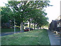
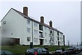
2
Green by flats in Donald Hall Road
in the Bristol Estate area of Brighton
Image: © Paul Gillett
Taken: 21 Mar 2013
0.03 miles
3
Donald Hall Road
In the Bristol Estate area of Brighton looking towards Whitehawk Hill
Image: © Paul Gillett
Taken: 2 Jan 2011
0.04 miles
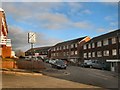
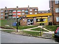
7
Donald Hall Road, Brighton
A residential road that is part of the Bristol Estate that was built in the 1950s. The road runs between Whitehawk Hill Road and Maresfield Road and is located to the rear of the Royal Sussex County Hospital.
Image: © Simon Carey
Taken: 13 Nov 2015
0.11 miles
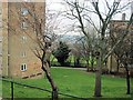
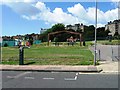
8
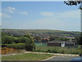
View east from Bristol Gate, Kemp Town, Brighton
Image: © Christopher Hilton
Taken: 6 Jul 2017
0.11 miles
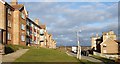
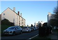
9
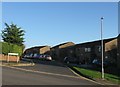
Slinfold Close, Brighton
A cul de sac off Whitehawk Hill Road that was built in 1974 and is part of the Bristol Estate. The steepness of the slope can be seen clearly here.
Image: © Simon Carey
Taken: 13 Nov 2015
0.12 miles