IMAGES TAKEN NEAR TO
Downsview Road, SEAFORD, BN25 4PT
Introduction
This page details the photographs taken nearby to Downsview Road, BN25 4PT by members of the Geograph project.
The Geograph project started in 2005 with the aim of publishing, organising and preserving representative images for every square kilometre of Great Britain, Ireland and the Isle of Man.

There are currently over 7.5m images from over14,400 individuals and you can help contribute to the project by visiting https://www.geograph.org.uk
Image Map
Images are licensed for reuse under creativecommons.org/licenses/by-sa/2.0
Notes
- Clicking on the map will re-center to the selected point.
- The higher the marker number, the further away the image location is from the centre of the postcode.
Image Listing (31 Images Found)
Images are licensed for reuse under creativecommons.org/licenses/by-sa/2.0
Image
Details
Distance
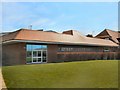
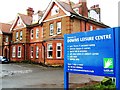
2
Deans Leisure Centre - Recreation ground
Image: © Paul Gillett
Taken: 10 Apr 2011
0.13 miles
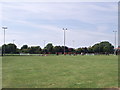
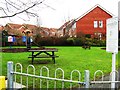
6
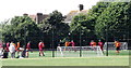
Football match, the Downs Leisure Centre, Seaford
The match is a friendly between Seaford Reserves and Polegate Town.
Image: © nick macneill
Taken: 30 Jul 2011
0.16 miles
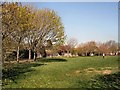
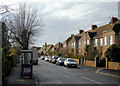
7
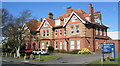
The Downs, Sutton Road, Seaford
Formerly a Girl's School.
Image: © Kevin Gordon
Taken: 21 Mar 2008
0.17 miles
8
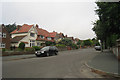
Southdown Road
Large pairs of semi-detached houses. A hundred metres North the road joins Sutton Road.
Image: © Oast House Archive
Taken: 3 Jul 2009
0.17 miles