IMAGES TAKEN NEAR TO
Hazeldene, SEAFORD, BN25 4NQ
Introduction
This page details the photographs taken nearby to Hazeldene, BN25 4NQ by members of the Geograph project.
The Geograph project started in 2005 with the aim of publishing, organising and preserving representative images for every square kilometre of Great Britain, Ireland and the Isle of Man.

There are currently over 7.5m images from over14,400 individuals and you can help contribute to the project by visiting https://www.geograph.org.uk
Image Map (39 Images)


Leaflet Map data © OpenStreetMap
Images are licensed for reuse under creativecommons.org/licenses/by-sa/2.0
Notes
- Clicking on the map will re-center to the selected point.
- The higher the marker number, the further away the image location is from the centre of the postcode.
Image Listing (39 Images Found)
Images are licensed for reuse under creativecommons.org/licenses/by-sa/2.0
Image
Details
Distance
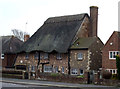
1
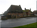
Thatch Cottage, Eastbourne Road, Seaford
Strange mish mash of styles with brickwork that suggests a lot of changes have been made. Yet the building is not on the 1888 OS map. This view looks south.
Image: © Simon Carey
Taken: 14 Feb 2006
0.02 miles
2
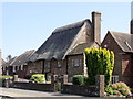
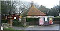
Thatched mock-medieval cottage, Seaford
Image: © nick macneill
Taken: 30 Jul 2011
0.07 miles
4
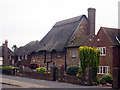
Thatched House on Eastbourne Road
Image: © Oast House Archive
Taken: 3 Jul 2009
0.08 miles
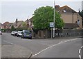
6
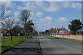
Sutton Avenue, Seaford
The sea in Seaford Bay can be seen on the horizon.
Image: © Kevin Gordon
Taken: 21 Mar 2008
0.08 miles