IMAGES TAKEN NEAR TO
Eastbourne Road, SEAFORD, BN25 4AB
Introduction
This page details the photographs taken nearby to Eastbourne Road, BN25 4AB by members of the Geograph project.
The Geograph project started in 2005 with the aim of publishing, organising and preserving representative images for every square kilometre of Great Britain, Ireland and the Isle of Man.

There are currently over 7.5m images from over14,400 individuals and you can help contribute to the project by visiting https://www.geograph.org.uk
Image Map
Images are licensed for reuse under creativecommons.org/licenses/by-sa/2.0
Notes
- Clicking on the map will re-center to the selected point.
- The higher the marker number, the further away the image location is from the centre of the postcode.
Image Listing (217 Images Found)
Images are licensed for reuse under creativecommons.org/licenses/by-sa/2.0
Image
Details
Distance
1
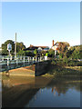
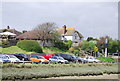
The Golden Galleon
A public house on the western side of the Cuckmere River opposite Exceat Bridge. Originally a cottage marked as Shepherd's Cottage on the 1874 OS map it appears to have been converted to a pub after the Second World War.
Image: © Simon Carey
Taken: 29 Oct 2013
0.02 miles
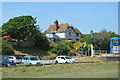
3
Golden Galleon, West Dean
Pub on Eastbourne Road.
Image: © Oast House Archive
Taken: 22 Apr 2011
0.02 miles
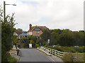
7
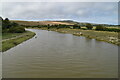
Cuckmere River
Taken just beyond Exceat Bridge as the river meanders towards the western side of the valley. The hill beyond is Ewe Down.
Image: © Simon Carey
Taken: 13 Jul 2008
0.02 miles
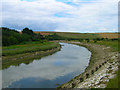
8
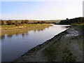
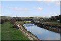
Cuckmere River
Looking downstream towards Exceat Bridge which can just be seen round the corner of the river. The property whose gate is here Image is just to the right of it. At this point the river cuts into the side of the chalk downs hence the shadow on the right hand side.
Image: © Simon Carey
Taken: 27 Jan 2008
0.03 miles
9
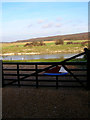
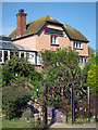
Across the River to Friston Forest
The gate marks the entrance to a property next to the Cuckmere River. Beyond the river is the flood plain whilst the horizon is marked by downland covered by the plantations of Friston Forest.
Image: © Simon Carey
Taken: 27 Jan 2008
0.03 miles