IMAGES TAKEN NEAR TO
Elgin Gardens, SEAFORD, BN25 3UR
Introduction
This page details the photographs taken nearby to Elgin Gardens, BN25 3UR by members of the Geograph project.
The Geograph project started in 2005 with the aim of publishing, organising and preserving representative images for every square kilometre of Great Britain, Ireland and the Isle of Man.

There are currently over 7.5m images from over14,400 individuals and you can help contribute to the project by visiting https://www.geograph.org.uk
Image Map
Images are licensed for reuse under creativecommons.org/licenses/by-sa/2.0
Notes
- Clicking on the map will re-center to the selected point.
- The higher the marker number, the further away the image location is from the centre of the postcode.
Image Listing (36 Images Found)
Images are licensed for reuse under creativecommons.org/licenses/by-sa/2.0
Image
Details
Distance
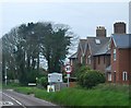
3
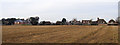
Chyngton Lane North, Seaford
Taken from the road that leads to Dymocks Farm Shop.
Image: © Kevin Gordon
Taken: 22 Dec 2007
0.06 miles

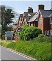
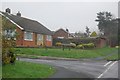
5
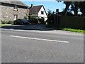
Cottages at the top of Chyngton Lane on the outskirts of Seaford
The bridleway runs south to the car park at Seaford Head.
Image: © Dave Spicer
Taken: 22 Jul 2012
0.07 miles
7
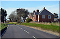
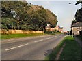
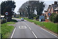
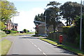
A259 Eastbourne Road enters Seaford
Seaford was a Cinque Port 1229-1883.
Image: © J.Hannan-Briggs
Taken: 17 Mar 2014
0.09 miles