IMAGES TAKEN NEAR TO
Manor Road North, SEAFORD, BN25 3RA
Introduction
This page details the photographs taken nearby to Manor Road North, BN25 3RA by members of the Geograph project.
The Geograph project started in 2005 with the aim of publishing, organising and preserving representative images for every square kilometre of Great Britain, Ireland and the Isle of Man.

There are currently over 7.5m images from over14,400 individuals and you can help contribute to the project by visiting https://www.geograph.org.uk
Image Map
Images are licensed for reuse under creativecommons.org/licenses/by-sa/2.0
Notes
- Clicking on the map will re-center to the selected point.
- The higher the marker number, the further away the image location is from the centre of the postcode.
Image Listing (36 Images Found)
Images are licensed for reuse under creativecommons.org/licenses/by-sa/2.0
Image
Details
Distance
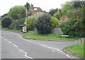
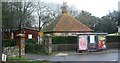
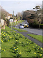
2
Crossroads on Eastbourne Road, Seaford
Junction with Manor Road.
Image: © J.Hannan-Briggs
Taken: 17 Mar 2014
0.04 miles
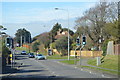
6
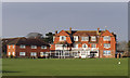
Newlands School, Seaford
With over 100 schools, Seaford once had one of the largest concentrations of schools in the UK. Today this school, Newlands, is the only independent school left in the town.
Image: © Kevin Gordon
Taken: 15 Mar 2008
0.08 miles
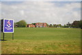
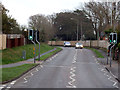
9
Eastbourne Road, Seaford
Showing the entrance (left) to Newlands School
Image: © Kevin Gordon
Taken: 15 Mar 2008
0.10 miles
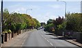
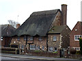
10
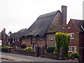
Thatched House on Eastbourne Road
Image: © Oast House Archive
Taken: 3 Jul 2009
0.10 miles