IMAGES TAKEN NEAR TO
Upper Sherwood Road, SEAFORD, BN25 3EA
Introduction
This page details the photographs taken nearby to Upper Sherwood Road, BN25 3EA by members of the Geograph project.
The Geograph project started in 2005 with the aim of publishing, organising and preserving representative images for every square kilometre of Great Britain, Ireland and the Isle of Man.

There are currently over 7.5m images from over14,400 individuals and you can help contribute to the project by visiting https://www.geograph.org.uk
Image Map
Images are licensed for reuse under creativecommons.org/licenses/by-sa/2.0
Notes
- Clicking on the map will re-center to the selected point.
- The higher the marker number, the further away the image location is from the centre of the postcode.
Image Listing (40 Images Found)
Images are licensed for reuse under creativecommons.org/licenses/by-sa/2.0
Image
Details
Distance
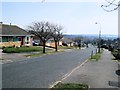
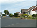
1
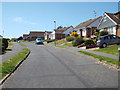
Northeast end of Upper Sherwood Road, Seaford
Image: © Robin Stott
Taken: 6 May 2014
0.03 miles
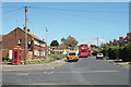
3
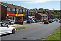
Local shops, southeast end of Lexden Road
They include an off-licence, a fish and chip shop, a hair salon and a newsagent. What more could one ask?
Image: © Robin Stott
Taken: 6 May 2014
0.08 miles
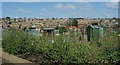
7
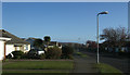
The Ridgeway, Seaford, East Sussex
With Seaford Head seen in the far distance.
Image: © Kevin Gordon
Taken: 13 Apr 2008
0.11 miles
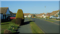
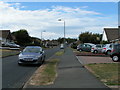
10
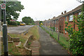
Etherton Way, Seaford
The housing here is on terraces on the slope.
Image: © Robin Webster
Taken: 15 Jul 2010
0.13 miles