IMAGES TAKEN NEAR TO
Royal Drive, SEAFORD, BN25 2XW
Introduction
This page details the photographs taken nearby to Royal Drive, BN25 2XW by members of the Geograph project.
The Geograph project started in 2005 with the aim of publishing, organising and preserving representative images for every square kilometre of Great Britain, Ireland and the Isle of Man.

There are currently over 7.5m images from over14,400 individuals and you can help contribute to the project by visiting https://www.geograph.org.uk
Image Map
Images are licensed for reuse under creativecommons.org/licenses/by-sa/2.0
Notes
- Clicking on the map will re-center to the selected point.
- The higher the marker number, the further away the image location is from the centre of the postcode.
Image Listing (13 Images Found)
Images are licensed for reuse under creativecommons.org/licenses/by-sa/2.0
Image
Details
Distance
1
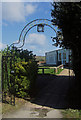
Bowden House School
Derelict school on Firle Road.
Image: © Oast House Archive
Taken: 22 May 2012
0.09 miles
4
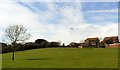
Green space in Princess Drive, Seaford
Image: © nick macneill
Taken: 12 Apr 2013
0.16 miles
5
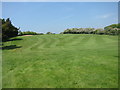
Seaford Golf Club, East Blatchington, East Sussex
Image: © Kevin Gordon
Taken: 21 Mar 2008
0.16 miles
6
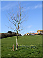
Annabels Tree, Princess Drive, Seaford
Houses in Grand Avenue on the horizon.
Image: © Kevin Gordon
Taken: 3 Mar 2008
0.18 miles
7
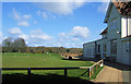
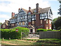
Club House, Seaford Golf Club, East Blatchington, Seaford, East Sussex
Image: © Kevin Gordon
Taken: 21 Mar 2008
0.18 miles
8
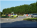
Entrance to Seaford Golf Club
Not to be confused with Seaford Head Golf Course, which is on the cliffs to the east of the beach.
Image: © Robin Webster
Taken: 6 Jul 2013
0.18 miles
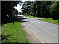
9
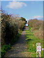
The old Grand Avenue, Seaford.
This was the old route of Grand Avenue before it was diverted further north. Some of the old road markings can still be seen on this stretch of road which is now a footpath.
Image: © Kevin Gordon
Taken: 3 Mar 2008
0.20 miles
10
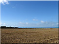
Silver Laine (1)
The name of the field according to Bishopstone's 1844 tithe map. The western end of Seaford lies at the far end of the field. See also Image
Image: © Simon Carey
Taken: 23 Aug 2012
0.21 miles