IMAGES TAKEN NEAR TO
Isabel Close, SEAFORD, BN25 2XE
Introduction
This page details the photographs taken nearby to Isabel Close, BN25 2XE by members of the Geograph project.
The Geograph project started in 2005 with the aim of publishing, organising and preserving representative images for every square kilometre of Great Britain, Ireland and the Isle of Man.

There are currently over 7.5m images from over14,400 individuals and you can help contribute to the project by visiting https://www.geograph.org.uk
Image Map
Images are licensed for reuse under creativecommons.org/licenses/by-sa/2.0
Notes
- Clicking on the map will re-center to the selected point.
- The higher the marker number, the further away the image location is from the centre of the postcode.
Image Listing (23 Images Found)
Images are licensed for reuse under creativecommons.org/licenses/by-sa/2.0
Image
Details
Distance
1
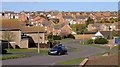
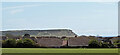
Valley Dip, Seaford
Beacon Road is in the foreground. Houses in Princess Drive, Alexandra Close, Katherine Way, Clementine Avenue and Isabel Close are also in shot.
Image: © Kevin Gordon
Taken: 3 Mar 2008
0.03 miles
2
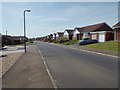
Alexandra Close, Seaford, East Sussex
With Beacon Drive running up the hill on the left.
Image: © Kevin Gordon
Taken: 9 Apr 2008
0.08 miles
3
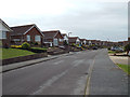
Beacon Drive from Katherine Way, Seaford
Image: © Kevin Gordon
Taken: 24 Jan 2007
0.12 miles
4
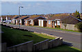
Victor Close, Seaford.
The sea can just be seen on the horizon as can the radio mast on Castle Hill, Newhaven.
Image: © Kevin Gordon
Taken: 3 Mar 2008
0.12 miles
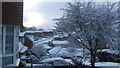
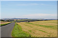
5
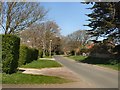
View to the SE from Grand Avenue
The houses of East Blatchington can be seen on the far side of the field (and within this grid square). The cliffs in the distance are at Seaford Head.
Image: © Ian Hawfinch
Taken: 7 May 2021
0.14 miles
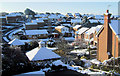
6
Southwest on Clementine Avenue, East Blatchington, Seaford
Image: © Robin Stott
Taken: 4 May 2014
0.15 miles
9
Grand Avenue, East Blatchingdon, and view over Bishopstone
Image: © Christopher Hilton
Taken: 17 Sep 2018
0.18 miles
10
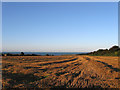
Upper Way Field (1)
The name of the field according to Bishopstone's 1844 tithe map that lies between the footpath and bridleway that link Bishopstone to East Blatchington though in effect it has been extended southwards to include Image It has also been split in two by the construction of Image in the late 1930s and would have been the site of a new coastal town had the war and tougher planning acts in its aftermath not intervened. This is the eastern side, see Image for the western portion.
Image: © Simon Carey
Taken: 26 Aug 2012
0.18 miles