IMAGES TAKEN NEAR TO
Beacon Close, SEAFORD, BN25 2JZ
Introduction
This page details the photographs taken nearby to Beacon Close, BN25 2JZ by members of the Geograph project.
The Geograph project started in 2005 with the aim of publishing, organising and preserving representative images for every square kilometre of Great Britain, Ireland and the Isle of Man.

There are currently over 7.5m images from over14,400 individuals and you can help contribute to the project by visiting https://www.geograph.org.uk
Image Map
Images are licensed for reuse under creativecommons.org/licenses/by-sa/2.0
Notes
- Clicking on the map will re-center to the selected point.
- The higher the marker number, the further away the image location is from the centre of the postcode.
Image Listing (15 Images Found)
Images are licensed for reuse under creativecommons.org/licenses/by-sa/2.0
Image
Details
Distance
1
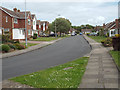
A bend on Kingsmead, Seaford
Shortly before it joins Beacon Drive, off to the left, near its junction with Carlton Road.
Image: © Robin Stott
Taken: 7 May 2014
0.07 miles
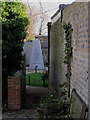
2
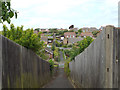
Footpath between Carlton Road and Clementine Avenue, Seaford
One of three footpaths from this side of Seaford heading northwest to Bishopstone. The other roads crossed by the footpath are Princess Drive and Churchill Road. It spans a valley.
Image: © Robin Stott
Taken: 7 May 2014
0.10 miles
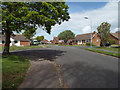
4
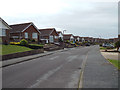
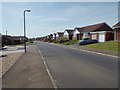
Victor Close, Seaford.
The sea can just be seen on the horizon as can the radio mast on Castle Hill, Newhaven.
Image: © Kevin Gordon
Taken: 3 Mar 2008
0.15 miles
5
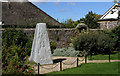
Kings Mead School War Memorial, Carlton Road, Seaford.
To commemorate the old boys of the former Kings Mead School who were killed in the second world war. Kings Mead School stood nearby until it was turned into a Nursing Home and later demolished for housing.
Image: © Kevin Gordon
Taken: 30 Jul 2007
0.15 miles
6
Kings Mead School War Memorial, Carlton Road, Seaford
The war memorial is two metres high and is of granite. It was unveiled by Lord Keyes in 2004.
Image: © Kevin Gordon
Taken: 1 Mar 2008
0.17 miles
7
Junction of Buckingham Close, Kingsmead and Kingsmead Walk, Seaford
Image: © Robin Stott
Taken: 7 May 2014
0.18 miles
8
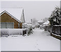
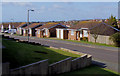
Kingsmead Lane, Seaford, East Sussex
Named after the old Kingsmead School which once stood on this site.
Image: © Kevin Gordon
Taken: 6 Apr 2008
0.19 miles
9
Southwest on Clementine Avenue, East Blatchington, Seaford
Image: © Robin Stott
Taken: 4 May 2014
0.20 miles
10
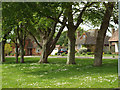
Through the trees, Firle Close, Seaford
The properties along and around Firle Road (the road to Seaford Golf Club) – large detached houses in spacious gardens – are in marked contrast to the housing estates to east and west: Image is one of several by Kevin Gordon that capture the ambience.
Image: © Robin Stott
Taken: 7 May 2014
0.20 miles