IMAGES TAKEN NEAR TO
Kingsmead, SEAFORD, BN25 2EZ
Introduction
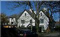
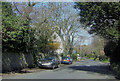
This page details the photographs taken nearby to Kingsmead, BN25 2EZ by members of the Geograph project.
The Geograph project started in 2005 with the aim of publishing, organising and preserving representative images for every square kilometre of Great Britain, Ireland and the Isle of Man.

There are currently over 7.5m images from over14,400 individuals and you can help contribute to the project by visiting https://www.geograph.org.uk
Image Map
Images are licensed for reuse under creativecommons.org/licenses/by-sa/2.0
Notes
- Clicking on the map will re-center to the selected point.
- The higher the marker number, the further away the image location is from the centre of the postcode.
Image Listing (66 Images Found)
Images are licensed for reuse under creativecommons.org/licenses/by-sa/2.0
Image
Details
Distance
1
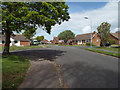
Junction of Buckingham Close, Kingsmead and Kingsmead Walk, Seaford
Image: © Robin Stott
Taken: 7 May 2014
0.02 miles
2
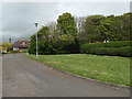
South side of Firle Close, Seaford
An older development by a property owner in nearby Firle Road. I think the story I was told was that the hedge across the middle of the open space is intended to screen the far properties from the headlights of cars entering the close.
Image: © Robin Stott
Taken: 7 May 2014
0.11 miles
3
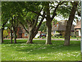
Through the trees, Firle Close, Seaford
The properties along and around Firle Road (the road to Seaford Golf Club) – large detached houses in spacious gardens – are in marked contrast to the housing estates to east and west: Image is one of several by Kevin Gordon that capture the ambience.
Image: © Robin Stott
Taken: 7 May 2014
0.11 miles
4
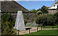
Kings Mead School War Memorial, Carlton Road, Seaford.
To commemorate the old boys of the former Kings Mead School who were killed in the second world war. Kings Mead School stood nearby until it was turned into a Nursing Home and later demolished for housing.
Image: © Kevin Gordon
Taken: 30 Jul 2007
0.11 miles
5
Blatchington House, Firle Road, East Blatchington, Seaford
Now a Retirement Home
Image: © Kevin Gordon
Taken: 21 Mar 2008
0.12 miles
6
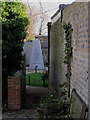
Kings Mead School War Memorial, Carlton Road, Seaford
The war memorial is two metres high and is of granite. It was unveiled by Lord Keyes in 2004.
Image: © Kevin Gordon
Taken: 1 Mar 2008
0.12 miles
7
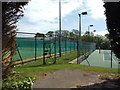
Seaford and Blatchington Lawn Tennis Club, Belgrave Road, Seaford
Image: © Robin Stott
Taken: 7 May 2014
0.13 miles
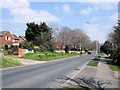
9
Firle Road, East Blatchington, Seaford
Once a track which led to West Firle.
Image: © Kevin Gordon
Taken: 21 Mar 2008
0.13 miles
10
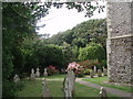
St Peter the Apostle Churchyard
St Peter the Apostle church dates back to the 12th Century. The church is of traditional Norman design and was built using locally quarried stone and flint.
More details: http://www.ukattraction.com/south-east-england/st-peter-the-apostle-church.htm
Image: © Paul Gillett
Taken: 20 Jul 2009
0.13 miles