IMAGES TAKEN NEAR TO
Sutton Park Road, SEAFORD, BN25 1UJ
Introduction
This page details the photographs taken nearby to Sutton Park Road, BN25 1UJ by members of the Geograph project.
The Geograph project started in 2005 with the aim of publishing, organising and preserving representative images for every square kilometre of Great Britain, Ireland and the Isle of Man.

There are currently over 7.5m images from over14,400 individuals and you can help contribute to the project by visiting https://www.geograph.org.uk
Image Map
Images are licensed for reuse under creativecommons.org/licenses/by-sa/2.0
Notes
- Clicking on the map will re-center to the selected point.
- The higher the marker number, the further away the image location is from the centre of the postcode.
Image Listing (339 Images Found)
Images are licensed for reuse under creativecommons.org/licenses/by-sa/2.0
Image
Details
Distance
1
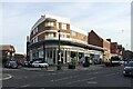
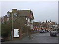
Covenience store and flats over, Sutton Park Road, Seaford
A building on this site, perhaps a villa or hotel, is first shown on a map of 1910 and is still there on a map of 1927. The present building must have been built after that: something like it appears on a map of 1938-50. Subsequent maps capture the distinctive plan; it is labelled Garage. Stacey Harris says, with her photo Image of 2009: "Formerly Caffyns car dealership".
Image: © Robin Stott
Taken: 19 Oct 2020
0.01 miles
2
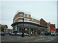
Tesco Supermarket, Seaford
Formerly Caffyns car dealership
Image: © Stacey Harris
Taken: 28 Jun 2009
0.01 miles
3
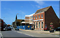
Sutton Park Road, Seaford
To the right of the Congregational Church are the blue hoardings protecting the former Caffyn's garage. The building on the right is the Midland (now HSBC) bank. The flowers are provided by "Seaford in Bloom".
Image: © Kevin Gordon
Taken: 26 Jun 2008
0.01 miles
4
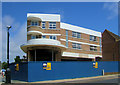
Former Caffyn's Garage, Clinton Place, Seaford
This splendid building with 1930s curves was built as a garage for Caffyns Limited. It was built on the site of Rostrevor, a house once occupied by Doctor William Pringle Morgan, the first person to identify dyslexia. The site was sold in 2007 and is being redeveloped to become a supermarket.
Image: © Kevin Gordon
Taken: 26 Jun 2008
0.01 miles
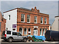
5
Stafford Road, Seaford
The sign is giving information about the Union Club
Image: © Robert Eva
Taken: 14 Mar 2020
0.01 miles
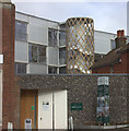
7
Former drill hall, Broad Street
Now under conversion to apartments.
Image: © Oast House Archive
Taken: 21 Jun 2014
0.02 miles
8

The Clinton Centre: late February 2016
Part of the Seaford Methodist/URC partnership
Image: © Basher Eyre
Taken: 28 Feb 2016
0.02 miles
9
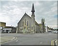
Seaford, Crossway Church
On Clinton Place, with a distinctive spire. A foundation stone dates the building to 1877; it is now shared by Methodists and URC. http://www.crosswayseafordchurch.co.uk/
Image: © Mike Faherty
Taken: 11 May 2019
0.02 miles
10
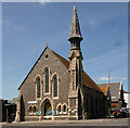
Seaford : Cross Way Church
Former Congregational church from 1877. Built to a design by architect W.F. Poulton.
Image: © Jim Osley
Taken: 27 May 2022
0.02 miles