IMAGES TAKEN NEAR TO
East Albany Road, SEAFORD, BN25 1TS
Introduction
This page details the photographs taken nearby to East Albany Road, BN25 1TS by members of the Geograph project.
The Geograph project started in 2005 with the aim of publishing, organising and preserving representative images for every square kilometre of Great Britain, Ireland and the Isle of Man.

There are currently over 7.5m images from over14,400 individuals and you can help contribute to the project by visiting https://www.geograph.org.uk
Image Map
Images are licensed for reuse under creativecommons.org/licenses/by-sa/2.0
Notes
- Clicking on the map will re-center to the selected point.
- The higher the marker number, the further away the image location is from the centre of the postcode.
Image Listing (36 Images Found)
Images are licensed for reuse under creativecommons.org/licenses/by-sa/2.0
Image
Details
Distance
2
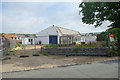
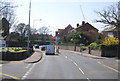
Vacant commercial premises, Seaford
On Sutton Drove.
Image: © Robin Webster
Taken: 15 Jul 2010
0.08 miles
5
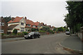
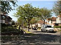
Southdown Road
Large pairs of semi-detached houses. A hundred metres North the road joins Sutton Road.
Image: © Oast House Archive
Taken: 3 Jul 2009
0.14 miles
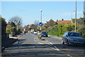
7
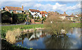
Blatchington Pond, Sutton Drove, Seaford, East Sussex
Image: © Kevin Gordon
Taken: 27 Mar 2008
0.15 miles
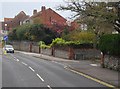
8
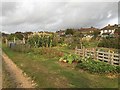
Allotments, Seaford
The allotments are managed by Seaford Town Council; they have benefited from Lottery funding. The site is reached from Sutton Drove. The view is towards houses in Hindover Road.
Image: © Robin Stott
Taken: 6 Sep 2019
0.16 miles

