IMAGES TAKEN NEAR TO
High Street, SEAFORD, BN25 1PP
Introduction
This page details the photographs taken nearby to High Street, BN25 1PP by members of the Geograph project.
The Geograph project started in 2005 with the aim of publishing, organising and preserving representative images for every square kilometre of Great Britain, Ireland and the Isle of Man.

There are currently over 7.5m images from over14,400 individuals and you can help contribute to the project by visiting https://www.geograph.org.uk
Image Map
Images are licensed for reuse under creativecommons.org/licenses/by-sa/2.0
Notes
- Clicking on the map will re-center to the selected point.
- The higher the marker number, the further away the image location is from the centre of the postcode.
Image Listing (312 Images Found)
Images are licensed for reuse under creativecommons.org/licenses/by-sa/2.0
Image
Details
Distance
4
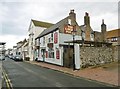
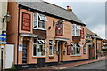
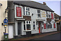
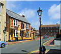
Seaford, Cinque Ports
Local at the eastern end of High Street; back counter, with eating and drinking area left, front and right, and games room at the back. Pool, pinball, darts, TV, games machine and an outside area. Cask ales on offer: Harvey's Bitter, Young's Bitter.
Image: © Mike Faherty
Taken: 11 May 2019
0.01 miles
6
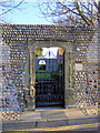
Tudor Gateway, Crouch Gardens, East Street, Seaford
The Tudor gateway was found in the cellars of the Old Town Hall. In 1952 Berry Brothers Ironmongers of Seaford made a wrought iron gate for it. There is therefore an Elizabethan Gate in an Elizabethan Gate!
Image: © Kevin Gordon
Taken: 15 Nov 2007
0.02 miles
8
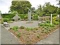
Seaford Peace Garden
Off East Street; a joint undertaking by the town council and local Quakers, and an opportunity for quiet reflection. https://www.eastbourneherald.co.uk/news/peace-garden-opens-in-the-crouch-1-1433394
Image: © Mike Faherty
Taken: 11 May 2019
0.03 miles
9
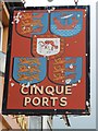
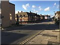
Cinque Ports Public House, High Street, Seaford
The Cinque Ports was previously named the Rising Sun. The space to the right of the pub was occupied in Victorian times by Banks the Bakers. The modern building at the end of the road (East Street) was previously the Albert Hall - the community centre of its day. The road on the right of the view is Crouch Lane.
Image: © Kevin Gordon
Taken: 26 Jun 2008
0.03 miles
10
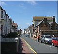
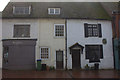
Upper High Street, Seaford
The row of houses on the left is called Penwatham Terrace, built opposite the Rising Sun Public House, now renamed The Cinque Ports. Seaford was a Cinque Port from the 13th century.
Image: © Kevin Gordon
Taken: 26 Jun 2008
0.03 miles