IMAGES TAKEN NEAR TO
Clinton Lane, SEAFORD, BN25 1NS
Introduction
This page details the photographs taken nearby to Clinton Lane, BN25 1NS by members of the Geograph project.
The Geograph project started in 2005 with the aim of publishing, organising and preserving representative images for every square kilometre of Great Britain, Ireland and the Isle of Man.

There are currently over 7.5m images from over14,400 individuals and you can help contribute to the project by visiting https://www.geograph.org.uk
Image Map
Images are licensed for reuse under creativecommons.org/licenses/by-sa/2.0
Notes
- Clicking on the map will re-center to the selected point.
- The higher the marker number, the further away the image location is from the centre of the postcode.
Image Listing (324 Images Found)
Images are licensed for reuse under creativecommons.org/licenses/by-sa/2.0
Image
Details
Distance
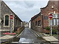
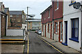
2
Clinton Lane, Seaford, East Sussex
This short road runs parallel to Clinton Place. The building at the end of the road is the old Caffyn's Garage. The building to the right of the telegraph pole with the orange roof is the Congregational Church Hall. (Now called the Crossway Centre)
Image: © Kevin Gordon
Taken: 25 Jun 2008
0.02 miles
3
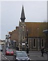
The Clinton Centre
A christian centre in the middle of Seaford.
Image: © N Chadwick
Taken: 29 Apr 2010
0.02 miles
4
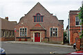
Old Market Cottages, Seaford
An odd name, as old maps show that this was a Sunday school. The current market is an occasional street market in Church Street, not very close, and I can't find any older location.
Image: © Robin Webster
Taken: 15 Jul 2010
0.02 miles
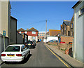
5
Clinton Lane, Seaford
The backs of shops on Clinton Place are on the left.
Image: © Robin Webster
Taken: 15 Jul 2010
0.02 miles
6
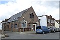
Old Market Cottages
On the corner of Clinton Place and Broad Street.
Behind the Old Market Cottages is the former Drill Hall Image
The Drill Hall was originally the Queen's Hall and was built in 1898. The Territorial Army took it over in 1904. Between the wars it was used as a concert hall. During the Second World War the Home Guard used this building as their HQ. Cadets were still using the building in 2009 https://seafordcurrents.wordpress.com/2011/08/26/whats-happening-to-the-drill-hall-in-seaford/ It has since been converted into apartments.
Image: © Gerald England
Taken: 27 Apr 2017
0.02 miles
7
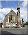
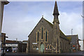
The Clinton Centre, Clinton Place, Seaford
Originally built in 1877 Image as a Congregational Church it subsequently became the Seaford United Reformed Church. In recent years it has functioned as a centre for performing arts and exhibitions and is shared with the Methodist congregation from the former Cross Way Church.
Image: © Gerald England
Taken: 27 Apr 2017
0.02 miles
8
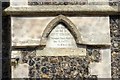
The former Seaford Congregational Church foundation stone
The foundation stone on what is now the Clinton Centre Image reads:
This Stone
was laid by
Mrs T, CROOK,
of Telsemaure House, Seaford.
Dec 7, 1877.
Rev E Green, Minister.
Image: © Gerald England
Taken: 27 Apr 2017
0.02 miles
10
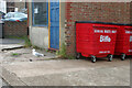
Bins and a Herring Gull, Seaford
Clinton Lane behind shops on Clinton Place.
Image: © Robin Webster
Taken: 15 Jul 2010
0.02 miles