IMAGES TAKEN NEAR TO
Pelham Road, SEAFORD, BN25 1EL
Introduction
This page details the photographs taken nearby to Pelham Road, BN25 1EL by members of the Geograph project.
The Geograph project started in 2005 with the aim of publishing, organising and preserving representative images for every square kilometre of Great Britain, Ireland and the Isle of Man.

There are currently over 7.5m images from over14,400 individuals and you can help contribute to the project by visiting https://www.geograph.org.uk
Image Map
Images are licensed for reuse under creativecommons.org/licenses/by-sa/2.0
Notes
- Clicking on the map will re-center to the selected point.
- The higher the marker number, the further away the image location is from the centre of the postcode.
Image Listing (394 Images Found)
Images are licensed for reuse under creativecommons.org/licenses/by-sa/2.0
Image
Details
Distance
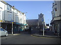
1
Seaford Police Station: late February 2016
Image: © Basher Eyre
Taken: 28 Feb 2016
0.02 miles
2
Flats at the north end of Pelham Road, Seaford
The brick-built flats are shown on hybrid satellite imagery as Welbeck Court. The flats over the shops in Dane Road, left, are called Dane Court. In shadow, left, is the blank brick side of the Morrisons supermarket; also seen is a bus stop for local services.
Image: © Robin Stott
Taken: 3 May 2014
0.02 miles
3
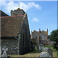
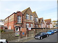
St Leonard's Church, Church Street, Seaford
On the left is the chapel of the Holy Spirit which was built in 1902 and dedicated in 1970. The building in the centre is the former Seaford Girls' Council School. It is now a nursery school.
Image: © Kevin Gordon
Taken: 27 Jun 2008
0.02 miles
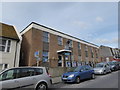
4
The Old School, Seaford: late February 2016
Half is now a kindergarten and half a health centre
Image: © Basher Eyre
Taken: 28 Feb 2016
0.03 miles
5
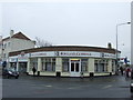
Estate Agent in Seaford
An estate agents' office in the Sussex coastal town of Seaford.
Image: © Malc McDonald
Taken: 17 Mar 2012
0.03 miles
6
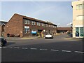
Seaford Health Centre, off Dane Road
This end of the extensive building is home to Seaford Medical Practice.
Image: © Robin Stott
Taken: 19 Oct 2020
0.03 miles
7
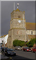
St. Leonard's Church Tower, Seaford
The tower is 21 metres tall with a red tiled 'Sussex Cap' roof. The tower was built in 1485 within the Norman walls of the church. There are no buttresses and scant foundations but the tower gets its strength from its thick walls. Note the chequerboard brickwork and the consecration cross under the clock.
Image: © Kevin Gordon
Taken: 8 Dec 2007
0.03 miles
8
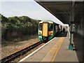
Train in Seaford Station
Seaford Station was opened on 1 June 1864 and was designed as a through station for a proposed extension to Eastbourne which was never built.
A working model of Seaford Station as it appeared in the 1920s is on display at Seaford Museum
http://en.wikipedia.org/wiki/Seaford_railway_station
Image: © Paul Gillett
Taken: 28 Mar 2010
0.03 miles
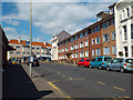
9
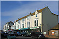
Church Street, Seaford, East Sussex
This row of shops has an Estate Agency (far left junction of Clinton Place) a Camera Shop, a Fish & Chip Shop, an Indian Restaurant and a Health Food shop. The small building on the far right at the junction of Place Lane is a public toilet.
Image: © Kevin Gordon
Taken: 25 Apr 2008
0.03 miles