IMAGES TAKEN NEAR TO
Dane Road, SEAFORD, BN25 1DL
Introduction
This page details the photographs taken nearby to Dane Road, BN25 1DL by members of the Geograph project.
The Geograph project started in 2005 with the aim of publishing, organising and preserving representative images for every square kilometre of Great Britain, Ireland and the Isle of Man.

There are currently over 7.5m images from over14,400 individuals and you can help contribute to the project by visiting https://www.geograph.org.uk
Image Map
Images are licensed for reuse under creativecommons.org/licenses/by-sa/2.0
Notes
- Clicking on the map will re-center to the selected point.
- The higher the marker number, the further away the image location is from the centre of the postcode.
Image Listing (384 Images Found)
Images are licensed for reuse under creativecommons.org/licenses/by-sa/2.0
Image
Details
Distance
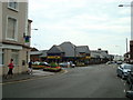
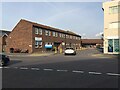
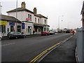
3
Flats at the north end of Pelham Road, Seaford
The brick-built flats are shown on hybrid satellite imagery as Welbeck Court. The flats over the shops in Dane Road, left, are called Dane Court. In shadow, left, is the blank brick side of the Morrisons supermarket; also seen is a bus stop for local services.
Image: © Robin Stott
Taken: 3 May 2014
0.03 miles
4
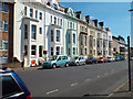
Pelham Place flats, Pelham Road, Seaford
Note the rounded corners to the window and door openings. The flats have a half-basement, making five storeys in all.
Image: © Robin Stott
Taken: 3 May 2014
0.03 miles
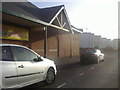
5
Seaford Health Centre, off Dane Road
This end of the extensive building is home to Seaford Medical Practice.
Image: © Robin Stott
Taken: 19 Oct 2020
0.04 miles
6
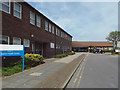
Seaford Health Centre, off Dane Road, Seaford
Image: © Robin Stott
Taken: 5 May 2014
0.04 miles
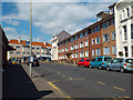
7
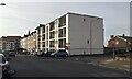
South on Pelham Road, Seaford
The near block of flats is Seaview Court. West Street crosses here.
Image: © Robin Stott
Taken: 19 Oct 2020
0.05 miles
8
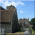
St Leonard's Church, Church Street, Seaford
On the left is the chapel of the Holy Spirit which was built in 1902 and dedicated in 1970. The building in the centre is the former Seaford Girls' Council School. It is now a nursery school.
Image: © Kevin Gordon
Taken: 27 Jun 2008
0.05 miles
9
Seaford station
The end of the branch line from Lewes. This looks north west up Station Approach from the roundabout.
Image: © Simon Carey
Taken: 14 Feb 2006
0.05 miles
10
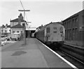
Seaford station, Sussex
With 2-HAP electric unit.
Image: © Dr Neil Clifton
Taken: 20 Jul 1979
0.05 miles