IMAGES TAKEN NEAR TO
Staplefield Drive, BRIGHTON, BN2 4RH
Introduction
This page details the photographs taken nearby to Staplefield Drive, BN2 4RH by members of the Geograph project.
The Geograph project started in 2005 with the aim of publishing, organising and preserving representative images for every square kilometre of Great Britain, Ireland and the Isle of Man.

There are currently over 7.5m images from over14,400 individuals and you can help contribute to the project by visiting https://www.geograph.org.uk
Image Map
Images are licensed for reuse under creativecommons.org/licenses/by-sa/2.0
Notes
- Clicking on the map will re-center to the selected point.
- The higher the marker number, the further away the image location is from the centre of the postcode.
Image Listing (11 Images Found)
Images are licensed for reuse under creativecommons.org/licenses/by-sa/2.0
Image
Details
Distance
1
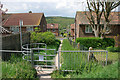
Kissing gate to the downs, Moulsecoomb
On the public footpath leading up from Staplefield Drive.
Image: © Robin Webster
Taken: 17 May 2010
0.00 miles
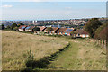
2
View over Moulescoomb
From a footpath up from Staplefield Drive.
Image: © Robin Webster
Taken: 17 May 2010
0.01 miles
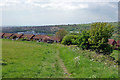
5
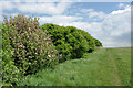
Apple blossom by footpath B48
Climbing Fulmer Hill away from Moulsecoomb.
Image: © Robin Webster
Taken: 17 May 2010
0.11 miles
6
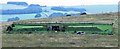
Reservoir on Bevendean Down
The photo shows the above ground superstructure of the reservoir built in the 1960s to supply water to the Bevendean Housing Estate.
Image: © Patrick Roper
Taken: 25 Aug 2010
0.18 miles
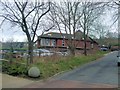
7
Hodshrove Road
Taken from outside Moulsecoomb Children's Centre
Image: © Paul Gillett
Taken: 10 Jul 2009
0.20 miles
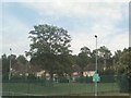
8
Moulsecoomb Health Centre
Provides clinics for the local community including district nursing, Smoking Cessation Clinics, Child psychology and counselling. Foot health, dental services and speech and language therapy, Enuretic Clinic. Community psychiatric nursing. Hearing aid supplies, contraceptive advice.
Image: © Paul Gillett
Taken: 27 Feb 2013
0.21 miles
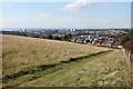
9
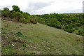
Hogtrough Bottom - grazed access downland
This downland has been divided by fences and part grazed by sheep. The top end of the bottom is largely scrub and is ungrazed. This slope is grazed, and has had some scrub cleared. It is looking very promising. No sheep were seen in mid-May, no doubt to enable downland plants to prosper.
Image: © Robin Webster
Taken: 17 May 2010
0.22 miles
10
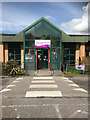
Moulsecoomb Community Leisure Centre
Centre run by Freedom Leisure https://www.freedom-leisure.co.uk/centres/moulsecoomb-community-leisure-centre/
Image: © Paul Gillett
Taken: 3 May 2018
0.23 miles