IMAGES TAKEN NEAR TO
The Hyde, BRIGHTON, BN2 4JU
Introduction
This page details the photographs taken nearby to The Hyde, BN2 4JU by members of the Geograph project.
The Geograph project started in 2005 with the aim of publishing, organising and preserving representative images for every square kilometre of Great Britain, Ireland and the Isle of Man.

There are currently over 7.5m images from over14,400 individuals and you can help contribute to the project by visiting https://www.geograph.org.uk
Image Map
Images are licensed for reuse under creativecommons.org/licenses/by-sa/2.0
Notes
- Clicking on the map will re-center to the selected point.
- The higher the marker number, the further away the image location is from the centre of the postcode.
Image Listing (21 Images Found)
Images are licensed for reuse under creativecommons.org/licenses/by-sa/2.0
Image
Details
Distance
1
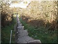
Jacobs ladder
Steps from Warren Road to Bevendean
Image: © Paul Gillett
Taken: 25 Oct 2009
0.06 miles
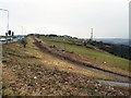
2
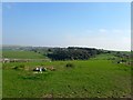
Race Hill
Viewed from the footpath that links Bear Road to Bevendean. Warren Road and the Race Course can be seen on the right whilst Bevendean Farm can be seen in the distance to the left.
Image: © Simon Carey
Taken: 11 Oct 2015
0.11 miles
3
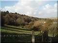
Hillside south of Bevendean
viewed from Jacob's Ladder
Image: © Paul Gillett
Taken: 25 Oct 2009
0.11 miles
4
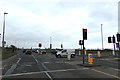
Warren Road
At the junction with Wilson Avenue near Brighton Race Course
Image: © Geographer
Taken: 22 Mar 2018
0.12 miles
5
Track near Warren Road
At the top of the hill above Bevendean near to Jacobs Ladder and Wilson's Avenue, the track is popular with horse riders.
Image: © Paul Gillett
Taken: 17 Feb 2012
0.14 miles
6
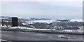
Warren Road
Warren Road provides a good viewpoint over a snowy Brighton in mid March.
Image: © Chris Thomas-Atkin
Taken: 18 Mar 2018
0.14 miles
7
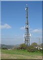
Communications Mast, Race Hill
There has been a communications mast at this spot since at least the 1950s when it was primarily a police wireless mast.
Image: © Simon Carey
Taken: 11 Oct 2015
0.17 miles
8
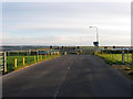
Wilson Avenue
Looking towards the junction with Warren Road. The road was built in the 1930s as an access route to the new estates at Whitehawk and Woodingdean. It begins at Roedean Road to the south then steeply climbs Race Hill. At this point it is crossed by Brighton Racecourse which necessitates the closure of the road during meetings when a layer of turf is placed over the tarmac. See also Image
Image: © Simon Carey
Taken: 29 Aug 2011
0.17 miles
9
Brighton Racecourse
Looking across Image as the track heads towards the peak of Race Hill then turns south towards the grandstand and finishing line.
Image: © Simon Carey
Taken: 29 Aug 2011
0.18 miles
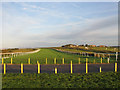
10

The Racecourse, Brighton
About one mile and two furlongs to the finishing line.
Brighton is one of the most undulating flat courses in the country and is often used for Derby trialists as it has some similarities to Epsom.
Image: © nick macneill
Taken: 15 Sep 2012
0.18 miles