IMAGES TAKEN NEAR TO
The Hyde, BRIGHTON, BN2 4JE
Introduction
This page details the photographs taken nearby to The Hyde, BN2 4JE by members of the Geograph project.
The Geograph project started in 2005 with the aim of publishing, organising and preserving representative images for every square kilometre of Great Britain, Ireland and the Isle of Man.

There are currently over 7.5m images from over14,400 individuals and you can help contribute to the project by visiting https://www.geograph.org.uk
Image Map
Images are licensed for reuse under creativecommons.org/licenses/by-sa/2.0
Notes
- Clicking on the map will re-center to the selected point.
- The higher the marker number, the further away the image location is from the centre of the postcode.
Image Listing (12 Images Found)
Images are licensed for reuse under creativecommons.org/licenses/by-sa/2.0
Image
Details
Distance
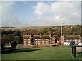
1
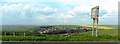
Bevendean from the Race Hill, Brighton
Image: © nick macneill
Taken: 13 Apr 2012
0.09 miles
2
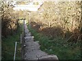
Jacobs ladder
Steps from Warren Road to Bevendean
Image: © Paul Gillett
Taken: 25 Oct 2009
0.15 miles
3
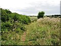
Meadowview wildlife corridor
A wildlife corridor that was managed by the Meadowside and Tenantry Community Action Group in 2010. The path leads eastwards to Racehill Valley.
Image: © Patrick Roper
Taken: 12 Aug 2010
0.19 miles
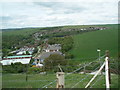
4
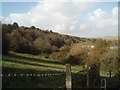
Hillside south of Bevendean
viewed from Jacob's Ladder
Image: © Paul Gillett
Taken: 25 Oct 2009
0.19 miles
5
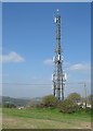
Communications Mast, Race Hill
There has been a communications mast at this spot since at least the 1950s when it was primarily a police wireless mast.
Image: © Simon Carey
Taken: 11 Oct 2015
0.20 miles
6
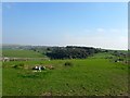
Race Hill
Viewed from the footpath that links Bear Road to Bevendean. Warren Road and the Race Course can be seen on the right whilst Bevendean Farm can be seen in the distance to the left.
Image: © Simon Carey
Taken: 11 Oct 2015
0.20 miles
7
Jacobs ladder
Steps lead down from Warren Road to Bevendean, see further down the steps Image
Image: © Paul Gillett
Taken: 3 May 2009
0.22 miles
8
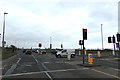
Warren Road
At the junction with Wilson Avenue near Brighton Race Course
Image: © Geographer
Taken: 22 Mar 2018
0.22 miles
9
Flats in Hornby Road
Bevendean Down is in the Background
Image: © Paul Gillett
Taken: 25 Oct 2009
0.22 miles
10
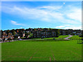
Lower Bevendean
Looking south across a school field towards Taunton Road. This is the farthest end of the estate.
Image: © Simon Carey
Taken: 9 Oct 2005
0.23 miles